Canada Slim and the Pirates of Teguise

Landschlacht, Switzerland, Sunday 5 May 2019

Imagine the perfect holiday.

Perhaps it is an active one spent hiking and windsurfing.

Perhaps you are a culture vulture mesmerized by museums and attracted to artefacts of days gone by.

Or perhaps you long for a lengthy siesta where your hardest decision is how much sunscreen to wear today.


Swissair logo.svg


The Canary Islands have what you want, however you want it, but being all things to all people means this is a place of contradictions.


The Islands lie off the coast of Africa yet they are European.


The Canary Islands form a Spanish archipelago and the southernmost autonomous community of Spain located in the Atlantic Ocean, 100 kilometres (62 miles) west of Morocco at the closest point.

The Canary Islands, which are also known informally as the Canaries, are among the outermost regions (OMR) of the European Union proper.

It is also one of the eight regions with special consideration of historical nationality recognized as such by the Spanish Government.

The Canary Islands belong to the African Plate, like the Spanish cities of Ceuta and Melilla on the African mainland.


Location of the Canary Islands within Spain


The seven main islands are (from largest to smallest in area) Tenerife, Fuerteventura, Gran Canaria, Lanzarote, La Palma, La Gomera and El Hierro.

The archipelago includes much smaller islands and islets: La Graciosa, Alegranza, Isla de Lobos, Montaña Clara, Roque del Oeste and Roque del Este.

It also includes a series of adjacent roques (those of Salmor, Fasnia, Bonanza, Garachico and Anaga).


In ancient times, the island chain was often referred to as “the Fortunate Isles“.

But delving into Canarian history the casual observer has to ponder the question:

Fortunate for whom?


Historically, the Canary Islands have been considered a bridge between four continents: Africa, North America, South America and Europe.

And it has been their strategic location that has been both a blessing and a curse to those who have chosen to make the Islands their home.


Flag of Canary Islands

Above: Flag of the Canary Islands


The archipelago’s beaches, climate and important natural attractions, especially Maspalomas in Gran Canaria and Teide National Park and Mount Teide (a World Heritage Site) in Tenerife (the third tallest volcano in the world measured from its base on the ocean floor), make it a major tourist destination with over 12 million visitors per year, especially Tenerife, Gran Canaria, Fuerteventura and Lanzarote.


Imagine living on an island where more people around you are tourists than residents.


Tourists are, by their very nature, selfish in that the pleasure principle dominates their every thought.

Most care nothing about those who reside there except in how the locals cater to their needs.


There is nothing new under the sun.


The islands have a subtropical climate, with long hot summers and moderately warm winters.

The precipitation levels and the level of maritime moderation vary depending on location and elevation.

Green areas as well as desert exist on the archipelago.

Rain seems rare and snow something never seen.


Due to their location above the temperature inversion layer, the high mountains of these islands are ideal for astronomical observation.

For this reason, two professional observatories, Teide Observatory on the island of Tenerife and Roque de los Muchachos Observatory on the island of La Palma, have been built on the islands.


The day sky is cloudless.

The night sky stretches to infinity and beyond.

The horizon beckons with promise.


So it may be reasonable to assume that piracy has existed for as long as the oceans were plied for commerce.


Piracy is an act of robbery or criminal violence by ship or boat-borne attackers upon another ship or a coastal area, typically with the goal of stealing cargo and other valuable items or properties.

Those who engage in acts of piracy are called pirates.

Privateering uses similar methods to piracy, but the captain acts under orders of the state authorizing the capture of merchant ships belonging to an enemy nation, making it a legitimate form of war-like activity by non-state actors.


Due to the strategic situation of this Spanish archipelago as a crossroads of maritime routes and commercial bridge between Europe, Africa and America, this was one of the places on the planet with the greatest pirate presence.

In the Canary Islands, the following stand out:

  • The attacks and continuous looting of Berber, English, French and Dutch corsairs
  • The presence of pirates from this archipelago who made their incursions into the Caribbean.
  • Pirates and corsairs, such as François Le Clerc, Jacques de Sores, Francis Drake, Pieter van der Does, Murat Reis and Horacio Nelson, attacked the islands.
  • Among those born in the archipelago who stands out above all is Amaro Pargo, whom the monarch Felipe V of Spain frequently benefited from his commercial incursions.


During the time of the Spanish Empire, the Canaries were the main stopover for Spanish galleons – galleons seeking to be laiden with treasure – on their way to the Americas, which came south to catch the prevailing northeasterly trade winds.


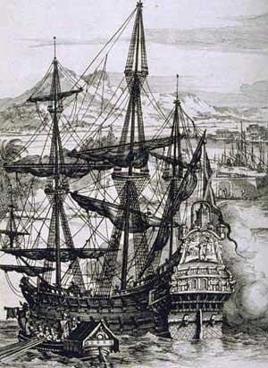
Sailing off the coast of Africa the closest of the Canaries to be reached is the Island of Lanzerote and thus it became the first Canary Island to be settled.


Lanzerote is the northernmost and easternmost of the autonomous Canary Islands in the Atlantic Ocean.

It is located approximately only 125 kilometres (78 miles) off the north coast of Africa and 1,000 kilometres (621 miles) from the Iberian Peninsula.

Covering 845.94 square kilometres (326.62 square miles), Lanzarote is the fourth largest of the islands in the archipelago.

With 149,183 inhabitants, it is the third most populous Canary Island, after Tenerife and Gran Canaria.

Located in the centre-west of the island is Timanfaya National Park, one of its main attractions.

The island was declared a biosphere reserve by UNESCO in 1993.

The island’s capital is Arrecife.


Spain Canary Islands location map Lanzarote.svg


The Phoenicians may have visited or settled there, though no material evidence survives.

The first known record came from Roman author Pliny the Elder in the encyclopaedia Naturalis Historia on an expedition to the Canary Islands.

The names of the islands (then called Insulae Fortunatae or the “Fortunate Isles“) were recorded as Junonia (Fuerteventura), Canaria (Gran Canaria), Ninguaria (Tenerife), Junonia Major (La Palma), Pluvialia (El Hierro), and Capraria (La Gomera).

Lanzarote and Fuerteventura, the two easternmost Canary Islands, were only mentioned as the archipelago of the “purple islands“.

The Roman poet Lucan and the Greek astronomer and geographer Ptolemy gave their precise locations.


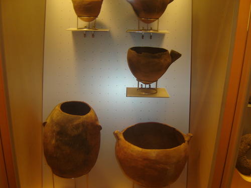
Several archaeological expeditions have uncovered the prehistoric settlement at the archaeologic site of El Bebedero in the village of Teguise.

In one of those expeditions, by a team from the University of Las Palmas de Gran Canaria and a team from the University of Zaragoza, yielded about 100 Roman potsherds, nine pieces of metal, and one piece of glass.

The artefacts were found in strata dated between the 1st and 4th centuries.

They show that Romans did trade with the Canarians, though there is no evidence of settlements.

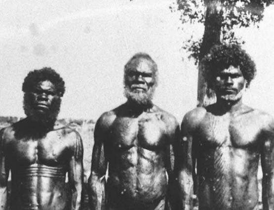
Lanzarote was previously settled by the Majos tribe of the Guanches, though the Romans did not mention them.


Guanches were the aboriginal inhabitants of the Canary Islands.

In 2017, the first genome-wide data from the Guanches confirmed a North African origin and that they were genetically most similar to modern North African Berber peoples of the nearby North African mainland.

It is believed that they migrated to the archipelago around 1000 BC or perhaps earlier.

The Guanches were the only native people known to have lived in the  region before the arrival of Europeans, as there is no evidence that the other archipelagos (Azores, Cape Verde, Madeira) were inhabited before Europeans arrived.

After the Spanish conquest of the Canaries they were ethnically and culturally absorbed by Spanish settlers, although elements of their culture survive to this day, intermixed within Canarian customs and traditions such as Silbo (the whistled language of La Gomera Island).


After the fall of the Western Roman Empire, the Canary Islands were ignored until 999, when the Arabs arrived at the island which they dubbed al-Djezir al-Khalida (among other names).

An account of the Guanche population may have been made around AD 1150 by the Arab geographer Muhammad al-Idrisi in the Nuzhatul Mushtaq, a book he wrote for King Roger II of Sicily, in which al-Idrisi reports a journey in the Atlantic Ocean made by the Mugharrarin (“the adventurers“), a family of Andalusian seafarers from Lisbon.

The only surviving version of this book, kept at the Bibliothèque Nationale de France, and first translated by Pierre Amédée Jaubert, reports that, after having reached an area of “sticky and stinking waters“, the Mugharrarin moved back and first reached an uninhabited island (Madeira or Hierro), where they found “a huge quantity of sheep, which its meat was bitter and inedible” and, then, “continued southward” and reached another island where they were soon surrounded by barks and brought to “a village whose inhabitants were often fair haired with long and flaxen hair and the women of a rare beauty“.

Among the villagers, one did speak Arabic and asked them where they came from.

Then the king of the village ordered them to bring them back to the continent where they were surprised to be welcomed by Berbers.

Apart from the marvelous and fanciful content of this history, this account would suggest that Guanches had sporadic contacts with populations from the mainland.

Al-Idrisi also described the Guanche men as tall and of a reddish-brown complexion.

During the 14th century, the Guanches are presumed to have had other contacts with Balearic seafarers from Spain, suggested by the presence of Balearic artifacts found on several of the Canary Islands.


Map of the Balearic Islands

Above: (in red) The Balearic Islands


In 1336, a ship arrived from Lisbon under the guidance of Genoese navigator Lancelotto Malocello, who used the alias “Lanzarote da Framqua“.

A fort was later built in the area of Montaña de Guanapay near today’s Teguise.


Castilian slaving expeditions in 1385 and 1393 seized hundreds of Guanches and sold them in Spain, initiating the slave trade in the islands.


Where there is profit to be found on the open seas there will be those who will seek to claim it.

Slavery and piracy differ only in that the plunder of the former is the lives of human beings.

The violence used by both is indistinguishable from the other.


French explorer Jean de Béthencourt arrived in 1402, heading a private expedition under Castilian auspices.

Bethencourt first visited the south of Lanzarote at Playa de Papagayo, and the French overran the island within a matter of months.


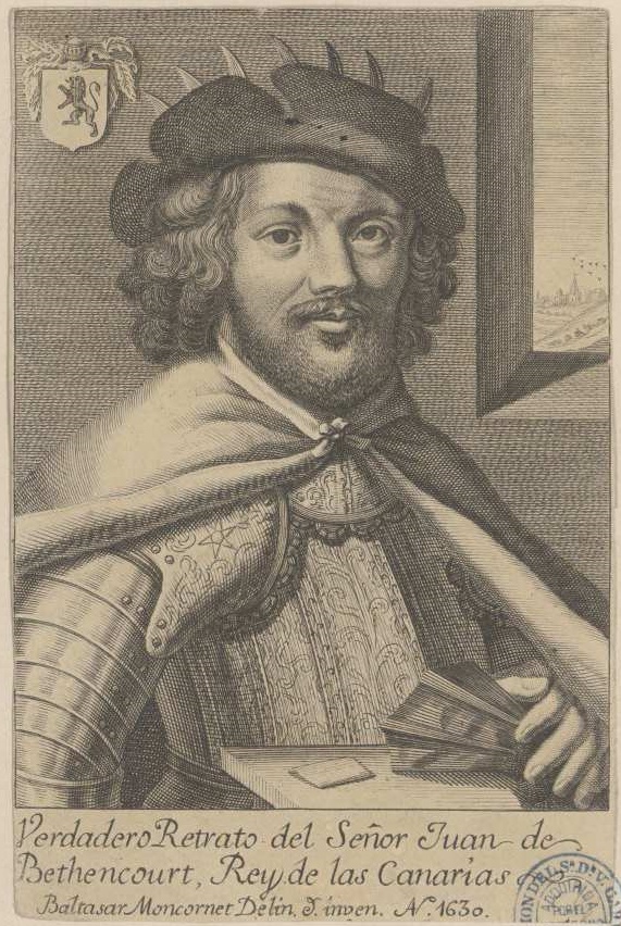
Above: Jean de Béthencourt (1362 – 1425)


The island lacked mountains and gorges to serve as hideouts for the remaining Guanche population and so many Guanches were taken away as slaves.

Only 300 Guanche men were said to have remained.


The Castilian conquest of the Canary Islands began in 1402, with the expedition of Jean de Béthencourt and Gadifer de la Salle (1340 – 1415) to the island of Lanzarote.

Gadifer would invade Lanzarote and Fuerteventura with ease since many of the aboriginals, faced with issues of starvation and poor agriculture, would surrender to Spanish rule.


At the southern end of the Yaiza municipality, the first European settlement in the Canary Islands appeared in 1402 in the area known as El Rubicón, where the conquest of the Archipelago began.

In this place, the Cathedral of Saint Martial of Limoges was built.

The cathedral was destroyed by English pirates in the 16th century.

The diocese was moved in 1483 to Las Palmas de Gran Canaria (Roman Catholic Diocese of Canarias).


Catedral Santa Ana.jpg


In 1404, the Castilians (with the support of the King of Castile) came and fought the local Guanches who were further decimated.

The islands of Fuerteventura and El Hierro were later similarly conquered.


In 1477, a decision by the royal council of Castile confirmed a grant of Lanzarote and Fuerteventura, with the smaller islands of Ferro and Gomera to the Castilian nobles Herrera, who held their fief until the end of the 18th century.

In 1585, the Ottoman admiral Murat Reis temporarily seized Lanzarote.

In the 17th century, pirates raided the island and took 1,000 inhabitants into slavery in Cueva de los Verdes.


From 1730 to 1736, the island was hit by a series of volcanic eruptions, producing 32 new volcanoes in a stretch of 18 kilometres (11 miles).

The priest of Yaiza, Don Andrés Lorenzo Curbelo, documented the eruption in detail until 1731.

Lava covered a quarter of the island’s surface, including the most fertile soil and 11 villages.

100 smaller volcanoes were located in the area called Montañas del Fuego, the “Mountains of Fire“.


In 1768, drought affected the deforested island and winter rains did not fall.

Much of the population was forced to emigrate to Cuba and the Americas, including a group which formed a significant addition to the Spanish settlers in Texas at San Antonio de Bexar in 1731.


Another volcanic eruption occurred within the range of Tiagua in 1824, which was less violent than the major eruption between 1730 and 1736.

Thus the island has become a UNESCO Biosphere Reserve protected site.


According to a report in the Financial Times, this status was endangered by a local corruption scandal.

Since May 2009, police have arrested the former president of Lanzarote, the former mayor of Arrecife and more than 20 politicians and businessmen in connection with illegal building permits along Lanzarote’s coastline.

UNESCO has threatened to revoke Lanzarote’s Biosphere Reserve status, “if the developments are not respecting local needs and are impacting on the environment“.

The President of the Cabildo of Lanzarote denied “any threat to Lanzarote’s UNESCO status“.

UNESCO logo English.svg


Piracy upon the open sea beside the shores of Lanzarote may be a thing of the past but greed remains eternal.


Teguise, Lanzarote, Canary Islands, Sunday 2 December 2018

As described in a previous post of this blog, my wife and I arrived on the island and drove from the airport near the island capital of Arrecife to the resort town of Costa Teguise where we overnighted for the entirety of our stay on Lanzarote.

(Please see Canada Slim and the Royal Retreat of this blog.)


Arrecife-Airport.jpg

Above: Lanzarote Airport


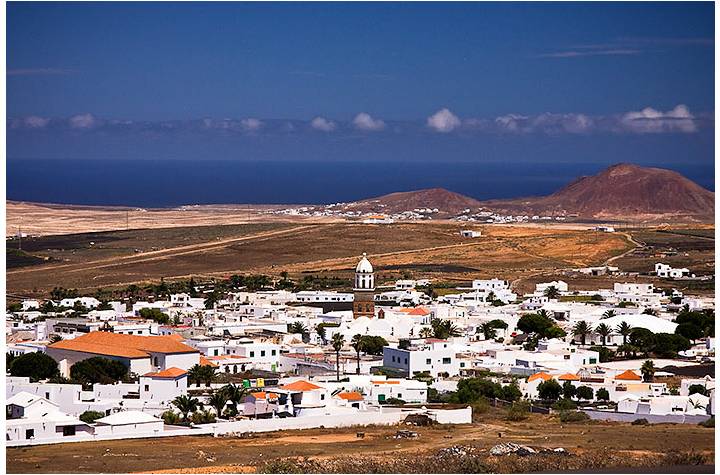
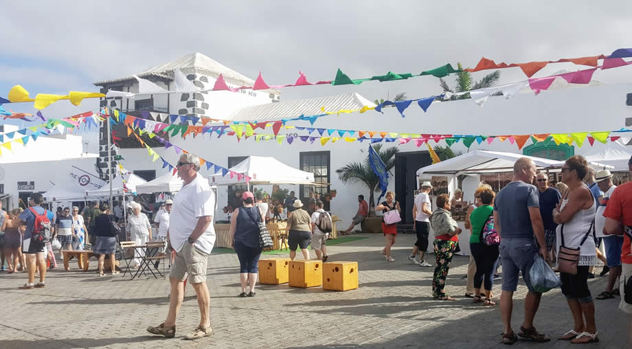
Our previous research gleaned that Sunday was market day in Teguise so soon after we checked into our hotel we quickly headed here.


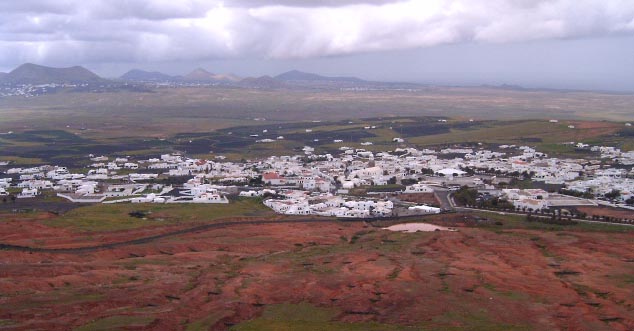
Teguise, also known as La Villa de Teguise, is a village in the Municipality of Teguise in the north central part of the Island, 12 km north of Arrecife.

Here North Africa meets Spanish pueblo.

Like no other place on Lanzarote, it has preserved its historic appearance to this day.

It is an intriguing mini-oasis of low buildings set around a central plaza and surrounded by the bare plains of central Lanzarote.

The small old town forms a compact whole that impresses in its uniformity.

The Andalusian style of southern Spain sets the tone.


Plaza Mayor


The outwardly simple, white houses have high, carved wooden portals and large shutters in front of the windows.

The former capital was built in the 15th century for fear of pirate raids in the middle of the island, right at the foot of the striking Montana de Guanapay.

Built in the Spanish colonial style, it presents a magnificent ensemble of stylish churches and monasteries, harmonious squares, magnificent old houses and quiet streets.

Old town Teguise has been a listed heritage site for over twenty years and is the jewel of Lanzarote.

It is considered one of the best preserved settlement centers of the Canaries.

As of 1 January 2018 the village’s population was 1,776.


The town was founded in 1418 and served as the capital of the Kingdom of the Canary Islands from 1425 to 1448 and as capital of Lanzarote until the capital was moved to Arrecife in 1852.

Teguise is said to have been founded by Maciot – the successor of the aforementioned Jean de Béthencourt – who is rumoured to have lived here with Princess Teguise, the daughter of the Guanche King Guadarfia.


Image result for teguise images


Various convents were founded and the town prospered.

But with prosperity came other problems, including pirates who plundered the town several times.


Although the strategic location of the city was favorable – protected to the north by the Famara reef, in addition to the Castillo de Santa Bárbara enthroned above the city, a broad overview in all directions, the following centuries were marked by numerous bloody pirate attacks, undoubtedly reactions to the brutal raids of Teguise’s feudal lords, who had previously deported thousands of Berbers to slavery on the African coasts.

Teguise went through hard times and was said to be no more than a miserable village with thatched huts.


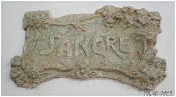
In 1586, Algerian pirates stormed the city under their infamous leader Morato Arráez and put down everything that stood in their way.

The Callejon de Sangre (Blood Alley) behind the parish church recalls this terrible tragedy.


Image result for callejon de la sangre teguise images


In 1618, plundering Berber hordes burnt down the city completely, enslaving much of the island’s population.

As a result, Teguise’s historic buildings were increasingly economically unattractive for most of the late 17th and 18th centuries.


And this is why, in 1852, the up-and-coming port city of Arrecife was named the new capital of the island, while Teguise evolved into the open-air museum that it still represents today.


Panorama Teguise nublado.jpg


Firmly on the tourist trail, there are several shops here selling flowing garments and handmade jewellery, plus restaurants, bars and a handful of monuments testifying to the fact that the town once was the capital.

This is a town of spacious squares and well-kept cobblestone streets lined with beautifully restored houses that testify to Teguise’s former glory.

For a stroll, however, you should choose a really sunny day, because Teguise is located in a relatively uncomfortable island corner, namely on a cold and draughty plateau.

During the week, Teguise is a quiet place, ideal for a leisurely stroll through the streets.


Sunday is all about the huge folksy market that takes place here every week.

It is a day of flourishing handicrafts in the market with throngs of tourists shopping and gorging themselves into a satiated stupor and locals lounging beneath a gentle breeze and a warm sun.

Throughout the entire old town, stands are close to one other, in between streams of visitors from the whole island crowded here for this one moment in time, the bars and restaurants bursting in an exuberant mood.

A day for dancing, if being leisurely was not so tempting.


Image result for teguise market sunday images


What strikes the visitor to Teguise Market the most is the foreign feel of the artists, the arts and crafts, the ecological and esoteric scene.

Various shops around the two central squares offer natural products, jewelery, antiques and so on – certainly not only because Teguise is so “beautiful“, but above all for tangible commercial reasons, because during the big Sunday market, the city is always very well attended.


But as well Canarian culture has a focus in Teguise.

Thus, the former capital of the island is considered the place of origin of the timples, the traditional guitar-like string instruments of Canarios, of which an exhibition in the Palacio Spinola proudly praises in the central square of Teguise.


The timple is a traditional 5-string plucked string instrument of the Canary Islands.

On La Palma Island and in the north of the island of Tenerife, many timple players omit the fifth (D) string, in order to play the timple as a four-string ukulele, though this is considered less traditional by players and advocates of the five-string version.

The players of the four-string style, in return, say that they are simply playing the timple in the old-fashioned way from before the time when a fifth string was introduced in the late nineteenth or early twentieth century.

Timple players (timplistas) of note are Benito Cabrera from Lanzarote, José Antonio Ramos, Totoyo Millares, and Germán López from Gran Canaria, and Pedro Izquierdo from Tenerife.


Antonio Lemes Hernández, at Calle Flores 8, is one of the last to build the famous Canarian guitars.

He also supplies many music groups in other Canary Islands.

Various sizes are produced, from the mini-model to the contratimple.

The Cabildo de Lanzarote, through its Departments of Culture and Industry, has recognized Antonio Lemes Hernández for his involvement of more than half a century in the production of timples.

Lemes, a craftsman from Teguise, has been building timples since he was very small.

He himself recognizes that:

“I have not done anything else, all my life making timples.
I made them out of cardboard as a child.

We brushed them and made them from that material, but of course, I made them and broke them, I did not have a teacher.” 

So he perfected his technique.

And to transform the wood….
I used to make them from polisandro, moral, mahogany, and the lid, which is always made of pine.

The important thing is that it is good wood so that they can tune well.


Image result for antonio lemes hernandez images


Sixty years after his first contact with the timple, Antonio’s hands continue to mold, giving life to the sound camel .

To play what is the treasure of Lanzerote music.


Antonio Lemes Hernández, popularly known as Lolo, was born in the stately Villa de Teguise.

As a child he learned the technique of woodworking in the School of Crafts of Teguise, although it was his carpenter companion, Antonio de León Bonilla, who had some knowledge of the timple, who taught him to shape the sound camel.

Little by little, Antonio became fond of this instrument, so today his works are highly valued and requested, some to make sound alone or at parties and others are conservative and wish to possess a timble like a real jewel in private storage.


Image result for antonio lemes hernandez images


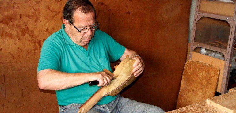
Antonio Lemes has always been linked to the world of music.

In his youth he was part of the famous orchestra of Teguise known as Lira and Lido and he was also a part of cultural institutions such as Rancho de Pascuas de Teguise.


At present, Antonio Lemes enjoys his retirement, although as he can not stand idly by, so every day he goes to his workshop located on Flores Street, where he continues to practice the work that made him fall in love as a child, the construction of the timple.


In 2016, the Guagime Folkloric Association of Tahíche showed him public recognition by giving him their highest award, the ‘Silver Insignia‘, for his dedication to the development of the timple.


The eclectic church, the Iglesia de Nuestra Senora de Guadalupe skulks in the town square.

Constructed in the mid-15th century, it has been rebuilt many times that it feels like the divine is in a perpetual state of confusion

Inside neo-Gothic furnishings surround a statue of the Virgin Mary of Guadalupe, but it was afternoon when we arrived in Teguise, so we were forced to imagine the scene rather than witness it for ourselves.


Teguise.jpg


On the opposite side of the square stands the Palacio Spinola.

The light of God facing the darkness of man.


The Palacio, completed after half a century in 1780, is beautiful with a small patio and a well.

It now doubles as both a museum and the official residence of the Canary Islands government.

It too was closed by the time we decided we wanted to visit it.


Image result for palacio spinola teguise images


This impressive edifice is host to the Casa del Timple – a museum dedicated to the small guitar like instrument which plays a big role in local folklore and tradtional music.


The building was renovated during the 1970´s by the ubiquitous César Manrique- and provides the perfect opportunity to step back in time and sample the lifestyle of an affluent nobleman in 18th century Lanzarote, whilst also learning more about the role of the timple in island life.


César Manrique

Above: César Manrique (1919 – 1992)

(“For me, Lanzarote was the most beautiful place on Earth, so I made it a point to show Lanzarote to the world.“)

(More on this amazing man in a future post….)


Today, echoes of the glorious past still resonate through Teguise´s cobbled streets – which are home to some fantastic old buildings and a wealth of colonial architecture that cannot be found anywhere else on Lanzarote.

Making La Villa, as it is known locally, one of the best-preserved historic centers in the whole of the Canary Islands.

Many of these buildings are now private residences and are therefore hidden away from public gaze behind green wooden shutters.

But the house-museum at the Palacio Spinola is open to the public.


The Palacio Spinola is located in the heart of Teguise in the Plaza de San Miguel – also known locally as the Plaza de Leones because of the two statues of lions that stand guard opposite the entrance to the Palace.

Construction on the building started in 1730 – the same year that the south of the island was subjected to a six-year volcanic eruption that forged the national park at Timanfaya.

These eruptions obviously disrupted life on Lanzarote and the building of the Palacio took another fifty years to complete.

The Palacio was originally known as the Inquisitors House – as it was once the HQ of the Holy Inquisition.

From the middle of the 18th Century it became home to the Feo Peraza family, the best known of whom was the policitican Jose Feo Armas.

But by 1895 the Palacio had passed into the hands of the wealthy Spinola family.

The impressive frontage of the building with its six huge windows enclosed by intricately carved wooden shutters is a clear indication of the prosperity of the original owners.


Image result for palacio spinola teguise


You needed serious money to afford this sort of opulence in the early 18th century.


Visitors walk through a formal entrance way, tiled with volcanic stone – where a small admission charge of €3 is made (free for children under 12 years) – and they are then free to explore the passageways and patios of the Palacio with the help of a basic printed guide which outlines the function of each room.

Amongst the most fascinating of these are the kitchens, with a chimney arrangement that is open to the elements in order to carry away cooking smoke, a latticed viewing gallery that overlooks the two main salons, or living rooms, a massive dining room with seating for thirty two guests and a small private family chapel, featuring an intricately carved wooden altar.

Throughout the Palacio, modern paintings by local artists, such as Aguilar, are juxtaposed with antique and reproduction furniture.

The exterior of the building is equally impressive, as long passageways lead visitors out into a delightful courtyard area that houses two stately old Canarian palm trees as well as a variety of flowering plants such as hibiscus and strelitza as well as an array of colourful succulents.

Here, visitors can observe the giant wooden door guarding the entranceway – built to a height that would allow both a horse and rider to enter unhindered.


Image result for palacio spinola images


The Palacio Spinola isn’t huge – comprising eleven rooms in total, so it will probably only occupy an hour or so of your time at best, but it is an extremely well preserved example of 18th century architecture.

And who knows – you might even bump into a modern day grandee.

As the Palacio Spinola is also now the official residence of the President of the Canary Islands when he is visiting Lanzarote.


Fernando Clavijo 2015 (cropped).jpg

Above: Fernando Clavijo Batlle, current President of the Canary Islands


Towering over the town is the Castillo de Santa Bárbara, built in the early 16th century on top of the 452-metre (1,480 foot) high Guanapay Peak and provides a view almost over the entire island.

Visible from afar, the fortress Santa Bárbara perches on a bare crater ridge above Teguise.

A real mini “knight’s castle” with massive masonry, drawbridge and small round towers awaits the visitor.

Inside, a pirate museum has been housed here for several years.


Image result for castillo santa barbara teguise images


The Museo de la Pirateria (Pirate Museum) has an exhibition that deals with an almost existential theme for Teguise and is also good for children.

With cartoon figures, picture stories, dioramas, historical signs and museum relics, the city’s hard times come to life again.

Excerpts from pirate films with six galleys from 1586 under Morato Arráez who conquers the castle and leaves Teguise with 200 prisoners, including the wife and daughter of the city commander Marquis Agustin Herrera y Rojas, for which Arráez finally receives 20,000 ducats for their ransom.


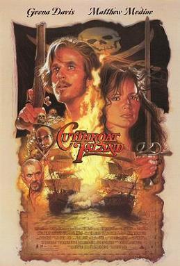
For me, Teguise, and most especially the Pirate Museum of Castle Bárbara, struck me as incongruous and felt somehow wrong.


Image result for museo de la piratería teguise images


Teguise had made a fortune from the slave trade until it was punished by Africans from whose populations these slaves had come.

The mercantile nature of the town, exhibited on a Christian day that is supposed to be free of commerce and labour, though less barbaric than former times, still resonates in the overpriced restaurants with substandard food and at the overvalued merchandise stalls where the buyer need be aware of deals done deceptively.


The Pirate Museum bothers me intensely, for it seems inherently callous to make profit from all the pain and violence committed by these bandits of the sea, celebrated and packaged glamourously for children’s consumption.

Pirates have always been and shall always be bloodthirsty bastards unable and unwilling to earn a honest day’s labour for the bread on the table.

How many hardworking families lost all that they had, including their lives, at the gory bloody hands of murderous, torturing and raping pirates?

And yet we have given pirates a mythical mystique of free men thirsting for liberty outside the confines of society.

We have made legends out of murderers, rapists and thievies and have given them colourful sobriquets like Blackbeard and Calico Jack.


Above: Pirate Cemetery, Île Sainte Marie, Madagascar


Beginning with Captain Charles Johnson’s A General History of the Robberies and Murders of the Most Notorious Pirates, piracy has become a celebrated cause since 1724.


Cover page of "A General History of the Pyrates" (1724) by Captain Charles Johnson.jpg


Since then we have had Long John Silver of Robert Louis Stevenson’s Treasure Island, Captain Hook as Peter Pan‘s aristocratic villain of J.M. Barrie’s play, and the sea stories of Rafael Sabatini.

These have led to films like Captain Blood, The Black Swan, and, of course, the immensely popular Pirates of the Caribbean franchise.


Captain Blood.jpeg


Somehow we have brainwashed ourselves with glamourous images of men walking the plank, being marooned, buried treasure, wooden legs and black eye patches, Jolly Roger flags and parrots squawking “pieces of eight, pieces of eight“.

Somehow we have come to warmly embrace and bring to life a seagoing world, befuddled twixt fact and fantasy, favouring felons of murderous, greedy, untrustworthy character, addicted to violence, crime committed casually, consciousness lacking conscience.

Somehow we don’t see unarmed fathers and sons viciously attacked, but instead we see elegant choreographed duels and sword fights, and not the bloody encounters where merciless men hack innocents down with axe and cutlass.

Real pirates bore little resemblance to Errol Flynn or Johnny Depp.


Jack Sparrow In Pirates of the Caribbean- At World's End.JPG

Above: Johnny Depp as Captain Jack Sparrow, Pirates of the Caribbean


And women aboard ship were rarer than chocolate truffles at a homeless shelter despite what Hollywood would have you believe with their lovely heroines playing a key role in the outcomes of their films.


Cutthroat island ver2.jpg


Pirates are a frequent topic in fiction and, in their Caribbean incarnation, are associated with certain stereotypical manners of speaking and dress, most of them wholly fictional:

Nearly all our notions of their behavior come from the golden age of fictional piracy, which reached its zenith in 1881 with the appearance of Robert Louis Stevenson’s Treasure Island.


Hugely influential in shaping the popular conception of pirates, Captain Charles Johnson’s A General History of the Pirates, published in London in 1724, is the prime source for the biographies of many well known pirates of the Golden Age.

The book gives a mythical status to pirates, with naval historian David Cordingly writing:

It has been said, and there seems no reason to question this, that Captain Johnson created the modern conception of pirates.

Such as a person costumed like the character of Captain Jack Sparrow, Johnny Depp’s lead role in the Pirates of the Caribbean film series.


Pirates of the Caribbean - The Curse of the Black Pearl.png


Some inventions of pirate culture such as “walking the plank“–in which a bound captive is forced to walk off a board extending over the sea–were popularized by J. M. Barrie’s novel, Peter Pan, where the fictional pirate Captain Hook and his crew helped define the fictional pirate archetype.


Peter pan 1911 pipes.jpg


English actor Robert Newton’s portrayal of Long John Silver in Disney’s 1950 film adaptation of Treasure Island also helped define the modern rendition of a pirate, including the stereotypical West Country “pirate accent“.


Treasure Island (1950 film) poster.jpg


Other influences include Sinbad the Sailor and the recent Pirates of the Caribbean films have helped rekindle modern interest in piracy and have performed well at the box office.


Sinbad the Sailor 1947 poster.jpg


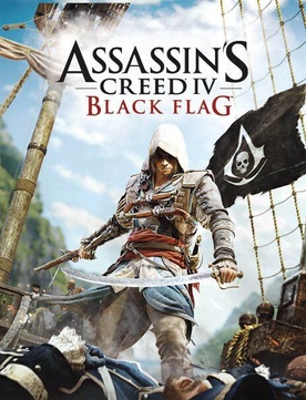
The video game Assassin’s Creed IV: Black Flag also revolves around pirates during the Golden Age of Piracy.


Assassin's Creed IV - Black Flag cover.jpg


The classic Gilbert and Sullivan comic opera The Pirates of Penzance focuses on The Pirate King and his hapless band of pirates.


Many sports teams use “pirate” or a related term such as “raider” or “buccaneer” as their nickname, based on these popular stereotypes of pirates.


Such teams include the Pittsburgh Pirates, who acquired their nickname in 1891 after “pirating” a player from another team.


MLB-NLC-PIT-Uniforms.png


The Oakland Raiders and Tampa Bay Buccaneers, both in the National Football League, also use pirate-related nicknames.


Oakland Raiders logo

Tampa Bay Buccaneers logo


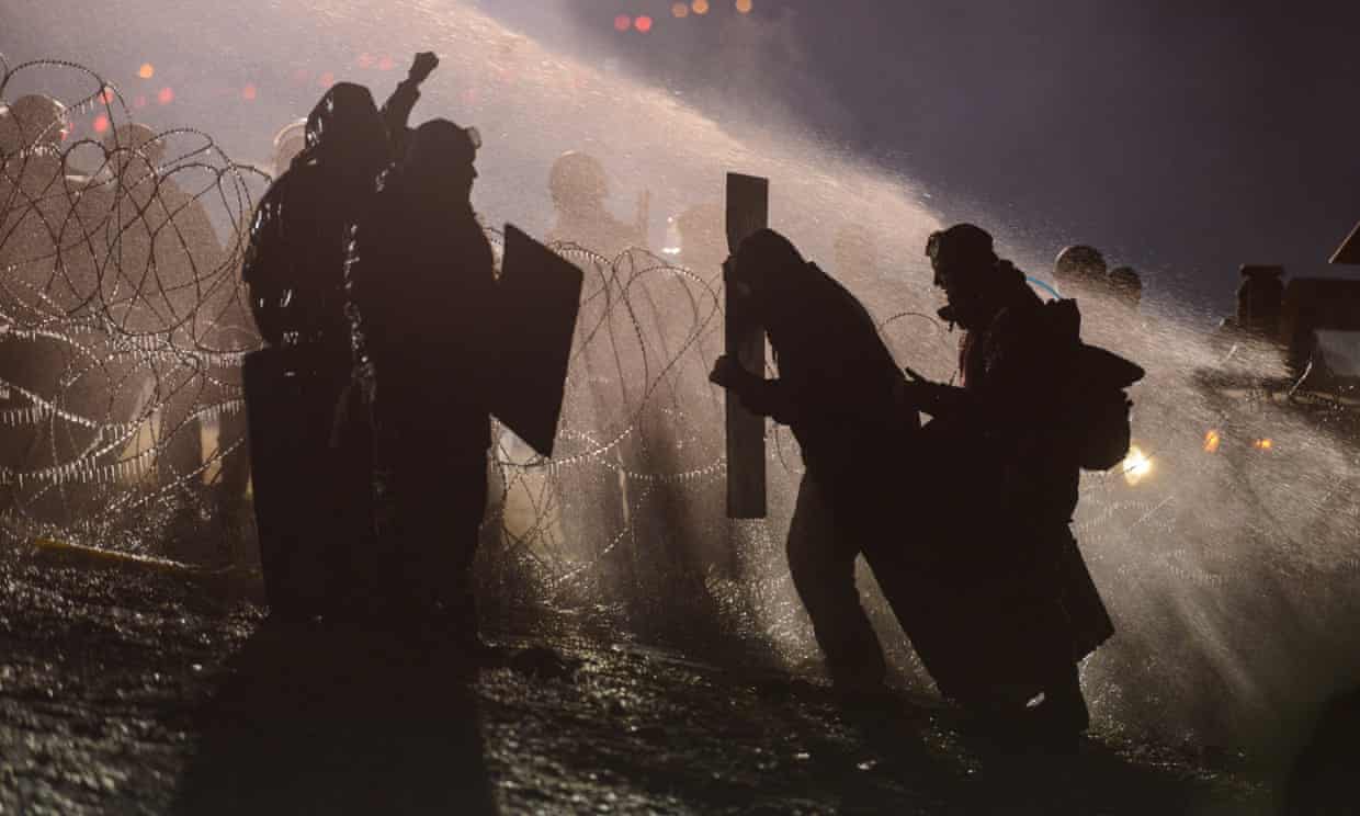
In the early 21st century, seaborne piracy against transport vessels remains a significant issue (with estimated worldwide losses of US$16 billion per year in 2004), particularly in the waters between the Red Sea and Indian Ocean, off the Somali coast, and also in the Strait of Malacca and Singapore.


Today, pirates armed with automatic weapons, such as assault rifles, and machine guns, grenades and rocket propelled grenades use small motorboats to attack and board ships, a tactic that takes advantage of the small number of crew members on modern cargo vessels and transport ships.

They also use larger vessels, known as “mother ships“, to supply the smaller motorboats.


Above: Somalian pirates


The international community is facing many challenges in bringing modern pirates to justice, as these attacks often occur in international waters.

Some nations have used their naval forces to protect private ships from pirate attacks and to pursue pirates, and some private vessels use armed security guards, high-pressure water cannons, or sound cannons to repel boarders, and use radar to avoid potential threats.


Piracy in the 21st century has taken place in a number of waters around the world, including the Gulf of Guinea, Strait of Malacca, Indian Ocean, and Falcon Lake.


Due to the crisis in Venezuela, issues of piracy returned to the Caribbean in the 2010s, with the increase of pirates being compared to piracy off the coast of Somalia due to the similar socioeconomic origins.

In 2016, former fishermen became pirates, appearing in the state of Sucre, with attacks happening almost daily and multiple killings occurring.

By 2018 as Venezuelans became more desperate, fears arose that Venezuelan pirates would spread throughout Caribbean waters.


Above: Gasoline smugglers, Limon River, Zulia State, Venezuela


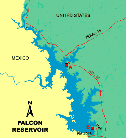
Piracy on Falcon Lake involves crime at the border between the United States and Mexico on Falcon Lake.

The lake is a 100-kilometre-long (60 mi) reservoir constructed in 1954 and is a known drug smuggling route.

A turf war between rival drug cartels for control of the lake began in March 2010 and has led to a series of armed robberies and shooting incidents.

All of the attacks were credited to the Los Zetas cartel and occurred primarily on the Mexican side of the reservoir but within sight of the Texas coast.

The so-called pirates operate “fleets” of small boats designed to seize fishermen and smuggle drugs.

While the events have been referred to colloquially as piracy, all the waters of Falcon Lake are considered either US or Mexican territorial waters and therefore are not technically piracy under Article 101 of the UN Convention on the Law of the Sea.


Image result for map of falcon lake


Piracy in the Gulf of Guinea affects a number of countries in West Africa as well as the wider international community.

By 2011, it had become an issue of global concern.

Pirates in the Gulf of Guinea are often part of heavily armed criminal enterprises, who employ violent methods to steal oil cargo.

In 2012, the International Maritime Bureau, Oceans Beyond Piracy and the Maritime Piracy Humanitarian Response Program reported that the number of vessels attacks by West African pirates had reached a world high, with 966 seafarers attacked during the year.


Piracy in the Gulf of Guinea has evolved over the first decade of the century.

For some time, smaller ships shuttling employees and materials belonging to the oil companies with any involvement in oil exploration had been at risk in Nigeria.

Over time, pirates became more aggressive and better armed.


Above: The Gulf of Guinea


As of 2014, pirate attacks in West Africa mainly occur in territorial waters, terminals and harbours rather than in the high seas.

This incident pattern has hindered intervention by international naval forces.


Pirates in the region operate a well-funded criminal industry, which includes established supply networks.

They are often part of heavily armed and sophisticated criminal enterprises, who increasingly use motherships to launch their attacks.

The local pirates’ overall aim is to steal oil cargo.

As such, they do not attach much importance to holding crew members and non-oil cargo and vessels for ransom.


Additionally, pirates in the Gulf of Guinea are especially noted for their violent modus operandi, which frequently involves the kidnapping, torture and shooting of crewmen.

The increasingly violent methods used by these groups is believed to be part of a conscious “business model” adopted by them, in which violence and intimidation plays a major role.


By 2010, 45, and, by 2011, 64 incidents were reported to the United Nations’ International Maritime Organization (UN – IMO).


However, many events go unreported.


International Maritime Organization Logo.svg


Piracy acts interfere with the legitimate trading interests of the affected countries that include Benin, Togo, Côte d’Ivoire, Ghana, Nigeria and the Democratic Republic of Congo.

As an example, trade of Benin’s major port, the Port of Cotonou, was reported in 2012 to have dropped by 70%.

The cost of piracy in the Gulf of Guinea due to stolen goods, security, and insurance has been estimated to be about $2 billion.

According to the Control Risks Group, pirate attacks in the Gulf of Guinea had by mid-November 2013 maintained a steady level of around 100 attempted hijackings in the year, a close second behind Southeast Asia.


Piracy in the Indian Ocean has been a threat to international shipping since the second phase of the civil war in Somalia in the early 21st century.

Since 2005, many international organizations have expressed concern over the rise in acts of piracy.

Piracy impeded the delivery of shipments and increased shipping expenses, costing an estimated $6.6 to $6.9 billion a year in global trade according to Oceans Beyond Piracy (OBP).


According to the German Institute for Economic Research (DIW), a veritable industry of profiteers also arose around the piracy.

Insurance companies significantly increased their profits from the pirate attacks as insurance companies hiked rate premiums in response.


Combined Task Force 150, a multinational coalition task force, took on the role of fighting the piracy by establishing a Maritime Security Patrol Area (MSPA) within the Gulf of Aden and Guardafui Channel.

By September 2012, the heyday of piracy in the Indian Ocean was reportedly over.


According to the International Maritime Bureau, pirate attacks had by October 2012 dropped to a six-year low, with only one ship attacked in the third quarter compared to thirty-six during the same period in 2011


By December 2013, the US Office of Naval Intelligence reported that only 9 vessels had been attacked during the year by the pirates, with zero successful hijackings.


Final ONI seal.jpg


Control Risks attributed this 90% decline in pirate activity from the corresponding period in 2012 to the adoption of best management practices by vessel owners and crews, armed private security onboard ships, a significant naval presence and the development of onshore security forces.


Pirates in the Strait of Malacca near Indonesia are normally armed with guns, knives, or machetes.

Many reports on attacks could have gone unreported because the companies are scared of the pirates attacking them more often because the company told the authorities.

The pirates in this area also attack ships during the night.

If vessels sound an alarm, the pirates usually leave without confronting the crew.

Pirates in the Singapore Straits attack at night, while ships are underway or anchored.


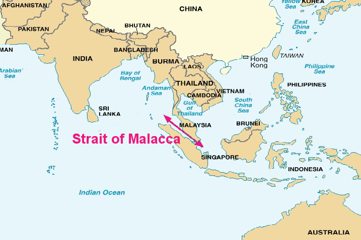
According to the Control Risks Group, pirate attacks in the Strait of Malacca had by mid-November 2013 reached a world high, surpassing those in the Gulf of Guinea.


I am all for generating income to feed a family and I realize that Teguise is highly dependent on tourism to feed theirs.

But a community that claims to be Christian should not be making a market day out of a day of rest and religious reflection.


I am all for having a museum that portrays reality historically accurate, but I find it objectionable to package criminal barbarity as a fun day out with the kids.

Piracy in all of its horror is not something that should be forgotten, but neither should it be glamorized nor sanitizied as entertainment for children.


Perhaps being a tourist is all about ignoring the realities of life, escaping from life.

But nothing is learned from life or travel if all we choose to see is only pleasureable.


Image result for teguise images


Teguise is a beautiful town worth visiting but it has forgotten what value truly is.

Heritage is not a commodity to be sold at the expense of faith.

Heritage is not a commodity to be sold at the expense of truth.


When houses of worship are ignored on a day of faith to increase a merchant’s profits….

When violent crime is packaged to sell tickets to children….

Then a community has sold its soul for filthy lucre.


I liked the streets of the town and the warm sunshine after the cold and damp of Switzerland, but I longed for real people uninterested in garnering money or attention from visitors.

Real folks content with living life on their own terms rather than that dictated by others.


Image result for teguise images


The aforementioned timple maker Antonio Lemes Hernandez is one.

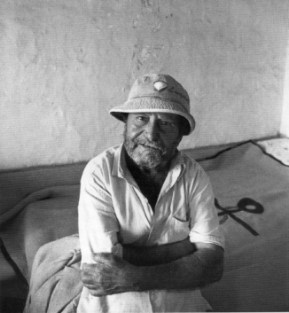
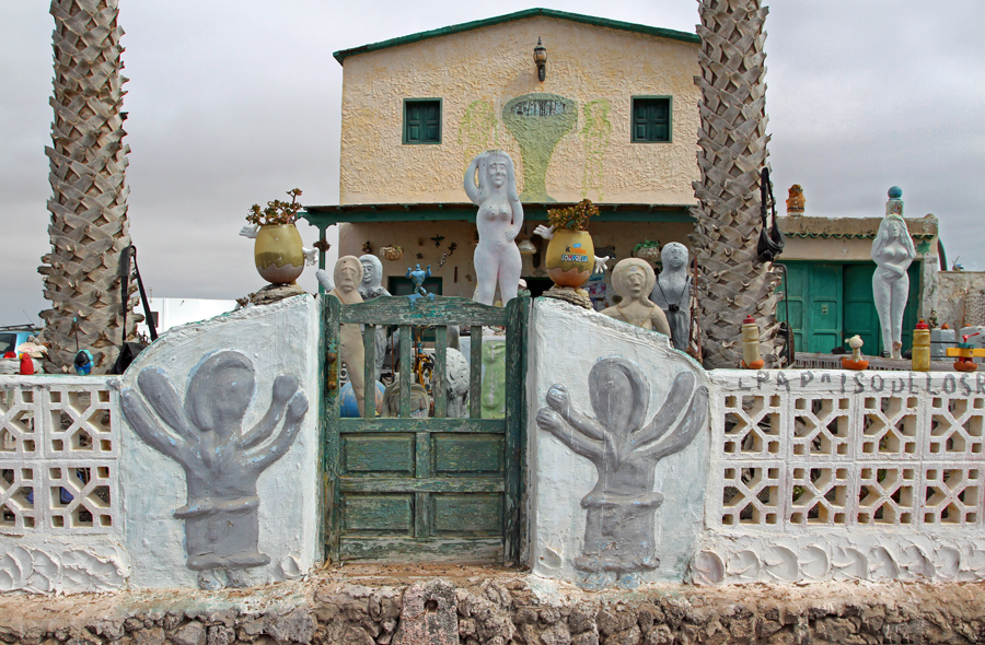
Don Pillimpo is another.


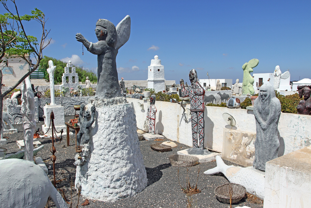
On the access road from Mozaga, diagonally across from the petrol station, there is a house with a garden full of original sculptures, everyday and art objects, children’s toys, teddy bears and dolls.


Image result for garden of don pillimpo teguise images


Pillimpo, who is actually known as José Garcia Martin, is constantly expanding and changing his unusual collection, the children of Teguise bring him their discarded toys, new color paintings enliven the large sculptures, unusual compositions call out for the viewer to notice.


Image result for don pillimpo images


This strange collection of statues frequently stops passers by in their tracks.

Cars pause in the road whilst their passengers stare.

Pedestrians stop to browse the chaotic display of figurines.

The colour of the statues change frequently, shades of grey, green and pale pink.


Image result for don pillimpo images


The house is referred to as the Casa Museo Mara Mao after the statue holding this name up.

The front door is generally open, although it is said the artist is shy about being photographed and doesn’t like people entering his garden.

Rogue dolls’ heads daubed with paint and teddy bears chained to the tree  have been embraced into this artist’s eclectic display.

In his 60’s Don Pillimpo is free to use his quirky imagination for everyone to wonder at.

Thousands, probably hundreds of thousands, pass the Pillimpo figurine park every year, but few people know the name of this artist.


Speechlessness, astonishment, amusement and helplessness is felt by those who pass by Pillimpos’s garden, as well as rejection, a sad shaking of the head, indifference, even fear.

But if you ask someone about these characters, who makes them, if they have any meaning, why Pillimpo dresses them in new colors over and over again, you only hear shrugs.

Maybe because it is not easy to approach the creator of this chaotic world?


Image result for don pillimpo images


Because the God of this Garden, of these saint sculptures, dolls, teddy bears, plush moose, Santa Clauses and action toy monsters with names like “Cloverfield” or “Zombie Spawn” does not show his world to the audience?

Pillimpo does not want to explain his world.

This world is dominated by larger than life figures of sand and cement, and the iconography reminds all those who grew up in the Christian context of saints that in the midst of society children have become disposable victims.


Image result for don pillimpo images


I never saw a greater balance between order and chaos, kitsch and authenticity.“, wrote a Spanish admirer of Pillimpos art on his blog.

Horrible.  I do not like it.  It’s just too heavy for me.“, an island-renowned German artist described his feelings about Pillimpo’s work.

Another artist looks at Pillimpos’s work from his own perspective of usual order and harmony:

So if my garden should look like this then you can instruct me!


So, is this art?


Image result for don pillimpo images


Art is a human cultural product, the result of a creative process.

The artwork is usually at the end of this process, but can also be the process itself.

Admiration, as such, is essential to art, but this does not have to be immediate in time and can only be the result of gaining knowledge.” is one definition of art according to Wikipedia.


Perception, imagination and intuition are some of the requirements for the artistic process.

Pillimpo’s creativity and imagination are innate to him, he says.

A gift from God that he believes in, for which he is grateful.

He emphasizes this again and again.

He knows his art is not universally loved.

In their opinion, I disturb the cityscape.“, says Pillimpo.


Image result for don pillimpo images


But they can not easily get rid of the man.

Thank God.


The land is his property.

The house in which he lives, and which is also inhabited by his creatures inside him, belongs to him.

He built it with his own hands.

No problem for the skilled bricklayer, who was born over half a century ago in his grandfather’s house near Teguise.


A hard time was the time of his youth, he recalls, and speaks of his mother, who gave birth to five more children, three girls and two boys.

Even as a young boy, Pillimpo had a thriving imagination.

Every morning, as he gazed at the sunbeams that filtered through the holes and cracks in the meagerly plastered walls, he was fascinated by the play of light and shadow and the forms his imagination accepted.

Too high reaching dreams for a boy from poverty, on Lanzarote, where at times, water was valuable, food scarce and schooling almost impossible.

Although little José could go to school, it was not fun for him.

When you come into the world, God has already given you all the skills you should have.

He gave me imagination.


Image result for don pillimpo images


Pillimpo leaves the subject quickly behind, almost as fast as the questions – about the meaning of his characters, whether he gives them names, why he always wraps them in new colors and how often he does that, where do the toys come from and why does his art matter – come flying at him.

It’s as if he does not hear these questions right.

He mentions that he gets the toys from local children.

He is happy when they look into his garden as they hold their parents’ hands and proudly point to their old teddy bear.

A special meaning?

Do his characters have names?

Names?  What names ?  No, they have no names.

As for the colours, I change, because I just enjoy it.

I love colors and I love all these things.“, says Pillimpo.


Image result for don pillimpo images


And, with that, the explanation is done for him.

Pillimpo goes into the house.

When he comes back, he has a magazine in his hand.

He leafs a bit until he finds what he’s looking for and then proudly shows an article about himself with many photos of his sculpture park and a poem.

He reads it aloud.

The interviewers are silent.

They go home but their thoughts remain in this other world for a long time.

In Pillimpos’s world.


In Pillimpos’s world, toys cast out of children’s rooms find a new home, new appreciation and attention.

A new place where they are admired or pitied.

Here, childlike feelings return to the adult.

No viewer can escape the power of this mixture of chaos and order, kitsch and originality.


Image result for don pillimpo images


Who is this man and why does he do what he does?

It is futile to ask others.

Nobody really knows anything about him.

There are only stories, rumours, now and then a grin.


Pillimpo began to scrape drawings in the sand with a stick and form figures out of loam, sand and water.

He often sits for hours, giving free rein to his imagination.


Not everyone likes that, but his mother had understood.

She had protected him, even defended his “quirks” from others, and did not laugh when he started to make music and dreamed of becoming an actor.


Related image


Pillimpo speaks of his dreams only to those able to exchange views with a true philosopher.

I would like to speak with a great thinker, so maybe I can know if I’m right in my views or if I’m a bit of a fool.“, he says seriously.


I cannot help but compare and contrast the Pirate Museum with the garden of Don Pillimpo.


The former forms the fantastic from facts best forgotten in the frentic thirst for profits.

The latter at no cost leaves a legacy of nostalgia for the children we once were.


The Museum claims to be history but it is not.

The garden makes no claims about being art but it is.


Teguise, for me, will never be about El Mercadillo (the name of this Sunday market) or the Castillo Santa Bárbara, despite how both dominate the attention.

Teguise is instead quiet humble pride whispered from a timple workshop and an eclectic sculpture garden.


And this is something no pirate could ever take from me.


Sources: Wikipedia / Google / Lonely Planet Canary Islands / DK Eyewitness Canary Islands / Eberhard Fohrer, Lanzarote / http://www.lanzarote37.net / https://lanzaroteinfomration.co.uk

Oil and Blood in the Heartland 2: Home and Native Land

Brantford, Ontario, Canada, Summer 1992

I embarrassed myself.

West of Hamilton and surrounded for the most part by farmland, Brantford is known for several things:

Official logo of Brantford

It lays claim to the invention of the telephone, the birthplace of “The Great One” hockey player Wayne Gretzky, entertainer Phil Hartman, Group of Seven painter Lawren Harris, and a Mohawk village.

Lawren Harris.JPG

Lawren Harris (1885 – 1970)

Phil Hartman (1948 – 1998), performing as Bill Clinton on Saturday Night Live

During my walking days exploring Canada I dutifully tried to visit as many cultural attractions as I could.

Alexander Graham Bell conceived the first telephone here on 26 July 1874.

Alexander Graham Bell.jpg

Alexander Graham Bell (1847 – 1922)

His first North American home, the Bell Homestead National Historic Site, has been painstakingly restored to its original condition.

A majestic, broad monument with figures mounted on pedestals to its left and right sides. Along the main portion of the monument are five figures mounted on a broad casting, including a man reclining, plus four floating female figures representing Inspiration, Knowledge, Joy, and Sorrow.

The Brantford Sports Hall of Recognition inside the Gretzy Centre has memorablia from dozens of local track, football, lacrosse and wrestling stars, but the main attraction is, of course, the permanent display for Wayne Gretzy.

It was here in this quiet town that Gretzy honed his game on the backyard hockey rink at his childhood home before shattering the NHL record books and blitzing his way to four Stanley Cups.

A small pair of ice skates, meant for a small child. The boot is leather and is missing its laces, while the blade is deteriorating and showing significant wear due to age.

Wayne Gretzy´s first pair of ice skates, age 3

But in 1992 these attractions did not draw my attention.

Southwest of town, the Six Nations territory has been a First Nations centre for centuries.

Captain Joseph Thayendanegea Brant led the Six Nations people (Mohawk, Oneida, Onondaga, Cayuga, Seneca and Tuscarora) here from New York State in 1784 and established a village that has long served the district´s First Nations tribes.

Joseph Brant painting by George Romney 1776 (2).jpg

Joseph Brant (Thayendanega)(1743-1807)

I visited the sites that celebrate their legacy:

Her Majesty´s Chapel of the Mohawks, three km from the centre of town, is the oldest Protestant Church in Ontario (1785) and the world´s only Royal Indian Chapel and the site of Captain Brant´s tomb.

Mohawk Chapel, Brantford, Ontario.jpg

The Woodland Cultural Centre serves as an indigenous performance space, an art gallery and a cultural museum, with exhibits following a timeline from prehistoric times through to contemporary native art.

The Chiefswood National Historic Site, across the street from the visitor centre, was the home of Mohawk poet Pauline Johnson, whose best-selling Flint and Feather poetry is truly a moving blend of European and aborginal cultures.

Tekahionwake ca 1895.jpg

Pauline Johnson (1861 – 1913)

The Six Nations of the Grand River Territory and the aborginal community of Ohsweken offers a glimpse of native life past and present and their Confederacy Band Council House remains a unifying cultural and political association which has helped settle disputes between bands and proudly represents and preserves First Nations heritage.

And it was here that I embarrassed myself.

I had arrived at a delicate time in aborginal – white relations in Canada.

The Oka Crisis of 1990 was still a sour memory and the seeds for the Grand River Land Dispute (2006) had just been planted.

The Oka Crisis was the first well-publicised violent conflict between First Nations and the Canadian government in modern times.

The Crisis developed from a local dispute between the town of Oka and the Mohawk community of Kanesatake, both just outside the metropolis of Montréal.

The town of Oka was developing plans to expand a golf course and residential development onto land that had been traditionally used by the Mohawk, including pineland and a burial ground marked by standing tombstones of their ancestors.

The town of Oka and its Mayor Jean Ouellete did not consult the Mohawk on the plans and no environmental or historic preservation review was taken.

Opponents of the plans found the Mayor´s office unwilling to discuss them.

So the Mohawks erected a barricade blocking access to the area.

Ouellete demanded compliance with the court order, but the protesters refused.

Ouellete asked the Sureté du Québec (SQ), Québec´s provincial police force, to intervene.

The SQ responded to the barricade by deploying tear gas and flash bang grenades.

Gunfire between both sides began.

After a 15-minute gun battle, SQ Corporal Marcel Lemay was killed and the police retreated.

The Mohawks seized six vehicles – four police cars and two front end loaders – and barricaded the main highway.

Natives from across Canada and the United States joined in and all roads that passed through Mohawk territory were blocked, including the Mercier Bridge, a major access point between the island of Montréal and the heavily populated South Shore of the St. Lawrence River.

Frustration over traffic congestion and the blocked roads led to residents of Chateauguay to burn an effigy of a Mohawk warrior while chanting “sauvages“.

The SQ having lost control of the situation were replaced by the Royal Canadian Mounted Police (RCMP) who proved equally ineffective and finally the Canadian military got involved.

The Oka Crisis lasted 78 days and the golf course was cancelled, but the issue of indigenous rights was far from resolved.

In 1992 Henco Industries purchased 40 hectares of land, the Douglas Creek Estates, from the Canadian government, which the Six Nations had never agreed to sell to Canada.

The Mohawks, after trying legal action to no avail, finally took action in 2006 in a manner similar to the Oka Crisis.

The Grand River land dispute at Caledonia, near Brantford, was held from 2006 to 2014.

Grand River land dispute, Potluck for Peace, 15 October 2006

I was asked by the Museum to write my opinion regarding aborginal rights, in the hopes I could understand their plight.

I responded to this request by writing that I was not responsible for what injustices my forefathers had done.

I committed the same error that many others have:

I treated the First Nations as if it were they and not us that had taken over the land.

It has taken decades of travel and experience to appreciate how much of a racist bigoted idiot I was to write those words and I wish that I could go back in time and give my younger self a swift kick in the ass for my ignorance and stupidity.

We, the white man, have not only over generations robbed our indigenous people of the most basic rights of physical survival and integrity, but as well have tried to destroy the preservation of their lands, languages, religions, heritage that are part of their existence as a people.

And we violate them by creating laws that ensure our rights over theirs.

And this cultural desecration has been going on for centuries against original peoples, whether it is Australian aborgines, New Zealand Maori, Canadian First Nations, American natives, Japanese Ainu…

The list is long…

Indigenous peoples and their interests are represented in the United Nations primarily through the mechanism of the Working Group in Indigenous Populations (UN-WGIP).

In April 2000 the United Nations Commission on Human Rights adopted a resolution to establish the United Nations Permanent Forum on Indigenous Issues (UN-PFII) as an advisory body to the Economic and Social Council with a mandate to review indigenous issues.

In September 2007, after a process of preparation, discussions and negotiations stretching back to 1982, the General Assembly adopted the Declaration of the Rights of Indigenous Peoples.

The non-binding Declaration outlines the individual and collective rights of indigenous peoples, as well as their rights to identity, culture, language, employment, health, education and other nations.

Of the 192 member countries of the United Nations, 11 nations abstained, 34 did not vote, the remaining 143 nations voted for the Declaration.

Standing Rock Indian Reservation, North/South Dakota, USA, 2016

Standing Rock is a Hunkpapa Lakota and Yanktonai Dakota native reservation straddling the North and South Dakotas boundary.

The 6th largest reservation in the United States, Standing Rock has a land area of 9,251 sq. km / 3, 571 sq. miles with a population of 8,500.

The Standing Rock Sioux Tribe is part of the Great Sioux Nation.

In 1868 the lands of the Great Sioux Nation were reduced in the Fort Laramie Treaty to the east side of the Missouri River and the state line of South Dakota in the west.

The Black Hills were considered by the Sioux to be sacred land and were located in the centre of territory awarded to the tribe.

In direct violation of the Treaty, General George Custer and his 7th Cavalry entered the Black Hills and discovered gold, starting a gold rush.

Custer Bvt MG Geo A 1865 LC-BH831-365-crop.jpg

Brevet Major General George Armstrong Custer (1839  -1876)

The United States government wanted to buy or rent the Black Hills from the Lakota people, but the Great Sioux Nation, led by their spiritual leader Sitting Bull, refused to sell or rent their lands.

Thus began the Great Sioux War / Black Hills War (1876 – 1877) between the Lakota Sioux and Northern Cheyenne versus the government of the United States.

Among the many battles and skirmishes of the War was the Battle of the Little Bighorn / Custer´s Last Stand / Battle of the Greasy Grass (25-26 June 1876) near the Little Bighorn River in eastern Montana, an overwhelming victory for the natives.

But that Battle notwithstanding, the United States with its superior resources was soon able to force the natives to surrender by attacking and destroying their encampments and property

The Agreement of 1877 officially annexed Sioux land and permanently established native reservations.

The US government took the Black Hills from the Sioux Nation.

In 1890, the US government broke a Lakota treaty by adjusting the Great Sioux Reservation into smaller parcels of land to permit white homesteaders to take some of land for agricultural / settlement purposes.

On the reduced reservations, the government allocated family units on 320-acre plots for individual households.

Although the Lakota were traditionally a nomadic people living in tipis and hunting buffalo and riding horses, they were now expected to farm and raise livestock.

With the goal of assimilation, the Lakota were forced to send their children to boarding schools, where they were taught English and Christianity and white cultural practices and the exclusion of traditional culture and language.

By the end of the 1890 growing season, a time of intense heat and little rainfall, it was clear that the assigned land would not produce substantial agriculture yields, and with the bison virtually eradicated, the Lakota were on the edge of extinction.

The Lakota turned to their heritage and their spiritual beliefs and took solace in their Ghost Dance rituals.

These rituals frightened the supervising agents of the Bureau of Indian Affairs.

Indian Affairs agent James McLaughlin asked for more troops, claiming that their spiritual leader Sitting Bull was the real leader of the movement.

En-chief-sitting-bull.jpg

Sitting Bull (1831 – 1890)

Former Agent Valentine McGillycuddy saw nothing extraordinary in the dances and ridiculed the panic that seemed to overcome the Agency:

“The coming of the troops has frightened the Indians.

If the Seventh Day Adventists prepare the Ascension robes for the Second Coming of the Saviour, the US Army is not put in motion to prevent them.

Why should not the Indians have the same privilege?

If the troops remain, trouble is sure to come.”

Nonetheless, thousands of additional US Army troops were deployed to the reservation.

On 15 December 1890, Sitting Bull was arrested for failing to stop his people from practicing the Ghost Dance.

During the incident, one of Sitting Bull´s men, Catch the Bear, fired at US Army Lieutenant Bullhead, striking his right side.

Bullhead instantly wheeled and shot Sitting Bull, hitting him in the left side.

Both men subsequently died.

The Hunkpapa fled to the south, joined the Big Foot band in Cherry Creek, South Dakota, then travelled to the Pine Ridge Reservation to meet with Chief Red Cloud.

The US 7th Cavalry caught them at a place called Wounded Knee on 29 December 1890, killing 300 people, including women and children.

Woundedknee1891.jpg

Burial of the dead after the Wounded Knee Massacre, 1890

Fast forward to the 1960s.

The US Army Corps of Engineers and the Bureau of Reclamation built five large dams on the Missouri River, implementing the Pick-Sloan Missouri Basin Program, forcing the natives to relocate from flooded areas.

Over 200,000 acres on the Standing Rock Reservation and the Cheyenne River Reservation in South Dakota were flooded just by the Oahe Dam alone.

Poverty remains a problem for the displaced population who still seek compensation for the loss of their towns submerged under Lake Oahe and the loss of their traditional ways of life.

Now we come to this year.

The Dakota Access Pipeline is a 1,134-mile/1,825 km long underground oil pipeline project, which begins in the Bakken oilfields in NW North Dakota and will travel SE through South Dakota and Iowa and end at the oil tank farm near Pakota, Illinois.

Dakota Access Pipeline route (Standing Rock Indian Reservation is shown in orange)[1][2]

Standing Rock Reservation (in orange) and the Pipeline´s projected route

Routing the Pipeline across the Missouri River near Bismarck was rejected because of the route´s proximity to Bismarck municipal water sources, residential areas, road, wetland and waterway crossings.

The alternative selected by the US Corps of Engineers crosses underneath the Missouri River half a mile from the Standing Rock Indian Reservation.

On 1 April 2016, elder member of the Standing Rock Sioux tribe LaDonna Bravebull Allard and her grandchildren established the Sacred Stone Camp to protest the Dakota Access Pipeline, which directly threatens the only water supply for the Standing Rock Reservation.

Sacred Stone is on her private land and is a centre for cultural preservation and spiritual resistance to the Dakota Access Pipeline.

Protests at the Pipeline site in North Dakota began and drew indigenous tribes from throughout North America, as well as many supporters, creating the largest gathering of native tribes in the past 100 years of US history.

“Of the 380 archeological sites that face desecration along the entire pipeline route, from North Dakota to Illinois, 26 of these are right here….

It is a historic trading ground, a place held sacred not only by the Sioux Nations, but also the Arikara, the Mandan and the Northern Cheyenne. 

The US government is wiping out our most important cultural and spiritual areas, and as it erases our footprint from the world, it erases us as a people. 

These sites must be protected or our world will end. 

It is that simple

Our young people have a right to know who they are. 

They have a right to language, to culture, to tradition. 

The way they learn these things is through connection to our lands and our history. 

If we allow an oil company to dig through and destroy our histories, our ancestors, our hearts and souls as a people, is that not genocide?”

By late September over 300 federally recognised native tribes and an estimated 4,000 pipeline resistance supporters resided at Sacred Stone, with several thousand more on weekends.

Peaceful protests at the pipeline site have continued and have drawn indigenous people from all over North America as well as other supporters.

North Dakota pipeline protest

On 3 September 2016, the South Dakota Access Pipeline brought in a private security firm.

The company used bulldozers containing native graves and burial artifacts.

When unarmed protestors moved near the bulldozers, the guards used pepper spray and guard dogs to protect the site they were told to guard.

Nine days later, a Colonial Pipeline leak spilled over 350,000 gallons of gasoline in Alabama, further fuelling the criticism of the Dakota Access Pipeline.

Since my last blog post, (I have been busy.), on the night of 21 November, in -5 degrees Celcius weather, law enforcement officers deployed tear gas and water hoses against hundreds of activists protesting against the Pipeline.

Standing Rock protests

Protestors were also hit with mace, pepper spray, rubber bullets and percussion grenades.

167 people were injured, 7 taken to hospital.

More than 400 activists have been arrested since the protests began.

The unarmed anti-pipeline activists call themselves “water protectors” and they stand unarmed against a highly-militarised police force defending a company that still lacks official permission to drill under the Missouri River.

And chances are strong that the water protectors will lose.

Americans won´t give up their dependance on fossil fuel, regardless of the technology and the capacity to do so that exists.

Flagge der Vereinigten Staaten

The US government has historically dishonoured itself by repeated violation of treaties signed with the native tribes and as oil company lobbies pay Congressmen more money than destitute native peoples can, the Pipeline will become yet another betrayal in a long list of betrayals.

Profit remains paramount over people.

And when pipelines break as they inevitably do and clean water becomes scarcer then gold then maybe America will realise the true folly of ignoring the message of Standing Rock.

When America, and the rest of the world, begins to realise that human rights and conservation are intertwined then there is the beginning of hope for the future.

All that there is now is the destruction of the past and the despoilation of the present and the prospect of a depressing future.

Fill ‘er up?

Sources: Wikipedia / The Guardian

The second encampment


Oil and Blood in the Heartland 1: Hope and Despair

Landschlacht, Switzerland, 8 November 2016

King Solomon of Israel (970 – 932 BC) once wrote about life on Earth in his day:

“A generation goes and a generation comes…

All things are full of weariness. 

A man cannot utter it. 

The eye is not satisfied with seeing nor the ear filled with hearing.

What has been is what will be. 

What has been done is what will be done.

There is nothing new under the sun.

Is there a thing of which it is said, “See, this is new.”?

It has been already in the ages before us.

There is no remembrance of former things, nor will there be any remembrance of later things yet to be, among those who come after.”

(Ecclesiastes 1: 4 – 11, Holy Bible, New International Version)

This is especially true in the Information Age.

Every day we see an endless procession of visual images and listen to an endless stream of sounds.

Yet, after all our looking and listening, our eyes and ears are not satisfied.

We still want to see and hear more.

So we take in more of the endless procession of sounds and images.

Enough is never enough.

There is always one more show to watch, one more game to play, one more song to listen to.

We keep texting, webcasting, Facebooking, Twittering and Flickring.

Facebook New Logo (2015).svg

Twitter bird logo 2012.svg

Flickr wordmark.svg

And it is all futile.

Life is more boring than modern man cares to admit.

Empires rise and fall.

War is followed by peace, then followed again by war.

As Yogi Berra said: “It´s déjà vu all over again.”

1953 Bowman Yogi Berra.jpg

What really changes?

The message or just the methods and speed?

Sickness or just the diagnostics and treatment?

Relationships?

Politics?

Morality?

The methods have changed, but the essence remains the same.

What was, is.

What is, will be.

Issues thought long past once again revisit.

The past unresolved meets the present moment, creating tensions for the future.

Again the winds of change blow across a familiar landscape.

Economics struggles against nature and tradition.

To be fair, there are moments of optimism.

“Eight miles off the coast of Long Beach, California, the oil rig Eureka, which has stood there for 40 years, looking like just another artifact of the modern industrial landscape, has beneath the waves a vast and thriving community of sea life – one of the richest marine ecosystems on the planet.

The location of Eureka and other rigs like it in this area, where a cold current sweeps down from Canada, has become a perfect habitat for fish and other sea life settling around the massive concrete pylons.

Momentum is gathering to convert rigs into artificial reefs once the rigs are decommissioned.

Awareness is increasing of the value of rigs as permanent homes for sea life.

But leaving rigs in place is controversial and is seen as benefiting the oil industry.

The Eureka, owned by the Houston oil company Beta Offshore, is one of 27 oil rigs off the California coast.

Several major oil spills have occurred since they were built half a century ago, giving rise to a passionate environmental movement that has long advocated complete removal of the rigs.

An enormous oil spill in 1969 released 100,000 barrels of crude, leaving a slick over 40 miles of coastline and killing thousands of animals.

In 2015, a pipeline sprung a leak that released 3,400 barrels of crude into the ocean, fouling several just-created marine protected areas.

The process of removing a rig and cleaning the site, known as decommissioning, is complicated and expensive, and includes plugging and cementing wells to make them safe.

A total decommissioning means the removal of the entire structure.

In a typical rigs-to-reefs effort, only the top portion is removed, usually to a depth of 80 feet, so that they don´t pose any risk to ship hulls.

The rest of the rig remains in place as a haven for sea life and for recreational diving or fishing.

The potential savings to the oil industry from converting all the rigs off the coast of California to reefs could be more than $1,000,000,000, but under US law oil companies would be required to put at least half the money they save into state coffers to fund conservation programs.”

(Erik Olsen, “Oil rigs gushing with marine life”, New York Times, 7 March 2016)

Reading of nature quietly reclaiming places despoiled by man does give me hope that no matter how man wrecks our planet that over time nature will repair itself.

But mankind acts swifter than nature reacts.

“Among Scots and tourists alike, the bonny banks of Loch Lomond have long been renowned as a relaxing place to enjoy some of the country´s most beautiful scenery.

Loch Lomond, looking south from Ben Lomond.jpg

The Australian company Scotgold Resources has spent most of the last decade developing a gold mine in the dramatic surroundings of Loch Lomond and the Trossachs National Park.

Local campaigners are voicing their concerns that the infrastructure and waste created by the operation could damage the national park.”

(The Independent, 25 February 2016)

“The juniper mesas and sunset-red canyons in a corner of southern Utah are so remote that even Republican Governor Gary Herbert says he has probably only seen them from the window of a plane.

2013-05-23 Gary R Herbert.JPG

This is a paradise for hikers and campers, a revered retreat where generations of the Original Peoples have hunted, gathered ceremonial herbs and carved their stories onto the sandstone walls.

Today, the land known as Bears Ears – named for twin buttes that jut over the horizon – is a battleground in the fight over how much power Washington exerts over federally controlled Western landscapes.

The President has the power under the Antiquities Act of 1906 to create national monuments on federal lands.

A coalition of native tribes, with support from conservation groups, is pushing for a new monument in these red rock deserts, arguing it would protect 1.9 million acres of culturally significant land from new mining and drilling.

But Utah lawmakers are so angry with federal land policies that in 2012 they passed a law demanding that Washington hand over 31 million acres, managed by the Bureau of Land Management, to the state.

Flag of the United States Bureau of Land Management.svg

The federal government – the landlord of 65% of Utah´s land – has not complied, so Utah is considering a $14,000,000 lawsuit to force a transfer.

Conservative lawmakers across the state have lined up to oppose any new monument.

Ranchers, county commissioners, business groups and even some local tribal members object to a monument as a land grab that would add crippling restrictions on animal grazing, oil and gas drilling and road building in a rural county that never saw its share of Utah´s economic growth.

For the coalition of tribes and nature advocates seeking preservation, a new national monument in Bears Ears would preserve a stretch of mountains, mesas and canyons six times the size of Los Angeles.

It could also create a new model for how public lands are managed.

The tribal coalition of Navajos, Zunis, Hopis, Utes and Ute Mountain Utes wants to jointly manage the land with the government.

“You can´t talk about who we are as a people without talking about the land.

The same kind of love that we have for relatives is no different than the love we have for the land.

Our traditional people know and understand these lands as living, breathing beings.” (Eric Descheenie, chairman of the intertribal coalition)

Utah´s Republican representatives in Salt Lake City and Washington overwhelmingly oppose President Obama and are pushing a bill that would conserve some stretches of land while allowing energy development in other parcels.

Environmental groups have largely denounced the plan, saying it would lead to more roads and traffic in the back country and open eastern Utah to tarsands extraction and new oil drilling.

Tribal groups pushing for a monument say they would have a far weaker voice in how the area was managed.

The Navajos have hunted and lived in the Bears Ears region long before Utah was called “Utah”.

People still go there to hunt elk or deer, gather wood for fence posts and herbs for ceremonies.”

(Jack Healy, “Remote Utah landscape becomes conservation battleground”, New York Times, 12 March 2016)

In a previous blog I wrote about how Oklahoma is being forced to put limits on oil and gas wells because the underground disposal of industrial wastes have triggered large earthquakes and how a health outreach initiative in Colorado is trying to dispel the notion that all tap water is harmful and how tourism operators are urging the Australian government to tackle climate change.

I spoke about how poachers have almost eliminated rhino species in Tanzania and how Australian company Mineral Commodities wishes to mine titanium on traditional South African land thus threatening social tradition and destruction of the local environment.

(See RIP Earth of this blog.)

Change challenges.

Economics versus tradition is a theme that never seems to fade.

Of course, there are voices that suggest there are other ways to satisfy our never-sated hunger for energy and profits, but these voices seem as distant from kind receptiveness as Bears Ears is from Salt Lake City…far away thus forgetable.

Yet some light does shine through the fog…

“In Britain, drivers of hydrogen fuel cell cars will soon be able to fill up at a network of stations that generate their fuel on site from renewable energy.

A ITM Power station in Teddington, southwest London, has opened with the capacity to produce hydrogen during periods when wind turbines are producing more power than the grid needs.

The station uses electrolysis to generate hydrogen from tap water.

The electrolyser takes power from the grid and can be switched on and off remotely to help the network remain in balance when there is excess supply of electricity.

Fuel cell cars combine hydrogen and oxygen to produce electricity, which powers the motor.

The Teddington station, based at the National Physical Laboratory, can claim to provide genuinely zero emission fuel when its electrolyser is running on renewable power.

ITM Power is opening several more hydrogen fuelling stations this year.

Fifteen are already in operation and the government is helping to fund a further 40 by 2020.

The Teddington station is part of the HyFive Project, an EU scheme that is supporting clusters of fuel cell cars and stations in Britain, Denmark and Germany.”

(Ben Webster, “Eco-filling station hopes to fuel rise of green cars”, The Times, 10 May 2016)

A reduction in carbon emissions from the use of fossil fuels is needed.

The average European emits around 12 tonnes of carbon a year into the atmosphere.

Carbon emissions are causing climate change.

But in some places like the US getting folks to reduce their carbon footprint is difficult.

SUVs (sport utility vehicles)(also known as 4 X 4s) are incredibly popular in the US, despite being dangerous both for pedestrians and the environment.

One in four vehicles sold in the US is an SUV.

SUVs are also gaining popularity in Europe.

SUVs are the most polluting form of passenger transport available.

Each gallon of petrol/gas burned emits more than 12 kilograms of CO2 and SUVs are gas guzzlers, doing as little as 13 miles per gallon.

I recall with bittersweet amusement the animated film Over the Hedge where RJ (a raccoon voiced by Bruce Willis) explains to the foraging animals he recently met how the world of humans operates:

Over the Hedge Poster.jpg

“THAT is an SUV. 

Humans ride around in it, because they are slowly losing their ability to walk.”

(Penny, the mother porcupine, voiced by Catherine O`Hara): Jeepers, it´s so big.

(Lou, the papa porcupine, voiced by Eugene Levy): How many humans fit in there?

(RJ): Usually? One.

The West is a car culture.

We love our cars, despite traffic noise, polluted air, dangerous driving, jam-packed streets and urban chaos.

We breathe in dangerous air pollutants and suffer from eye and throat irritation, cancer and damage to the body´s immune, neurological, reproductive and respiratory systems.

We destroy without compassion or concern our ponds, streams, fields and forests to produce electricity for our homes and to power our transportation.

When I read articles like the ITM Power hydrogen fuel station I feel a spark of optimism, but often I fear the world is heading madly towards becoming an environmental dystopia, as predicted by futurists like Thomas Malthus, Harry Harrison and George Orwell, or as feared in movies like Blade Runner, Elysium, No Blade of Grass, Silent Running, Soylent Green and WALL-E.

Elysium Poster.jpg

Soylent green.jpg

WALL-Eposter.jpg

“The world´s first international treaty that bans or phases out fossil fuels is being considered by leaders of developing Pacific island nations after a summit in the Solomon Islands in June.

The leaders of 14 countries agreed to consider a proposed Pacific climate treaty, which will bind signatories to targets for renewable energy and ban new or the expansion of existing coalmines, at the annual leadership summit of the Pacific Islands Development Forum (PIDF).

The treaty proposal was received very positively by the national leaders, who seemed convinced that the treaty is an avenue where the Pacific could again show or build on the moral and political leadership that they showed earlier in their efforts to tackle climate change.

The treaty will bind parties to not approve any new coal or fossil fuel mines and not provide any subsidies for fossil fuel mining or consumption.

The parties will ensure universal access to clean energy by 2030 and will establish a Pacific framework for renewable energy to achieve that goal.

The treaty, to be signed next year, will establish compensation for communities that have suffered climate change-related losses.

The treaty also has provisions on climate-related migration and adaptation.”

(Michael Slezak, “Pacific island nations consider world´s first treaty to ban fossil fuels”, The Guardian, 14 July 2016)

Even my part-time employer seems concerned about the environment…

“Starbucks is to try a fully recyclable cup as part of efforts to cut the amount of waste sent to landfills each year.

Starbucks Corporation Logo 2011.svg

The coffee shop chain will be the first retailer to test the Frugalpac, which, according to its manufacturer, is much easier to recycle.

More than 2.5 billion coffee cups are used in the UK every year, but only one in 400 is recyclable, with the rest sent to landfills or incinerated because they are made from paper laminated with plastic, making them hard to process.

Starbucks, which has 850 shops in the UK, has said that it will test the new cup in some of the shops “to see if the Frugalpac cup meets Starbucks standards for safety and quality.”

(Andrew Ellson, “Starbucks leads the way with fully recyclable coffee cup”, The Times, 22 July 2016)

But old habits and old attitudes die hard…

Let´s take a gander at my home and native land of Canada, a country which seems to be experiencing a love-in from many other countries and much of the media, like The Economist (“Liberty moves north: Canada´s example to the world”, 29 October 2016) or Monocle (“Canada calling: why it´s time to take a fresh look north”, November 2016).

Flag of Canada

According to The Economist, Canada is “a citadel of decency, tolerance and good sense” and says “the world owes Canada gratitude for reminding it of what many people are in danger of forgetting: that tolerance and openness are wellsprings of security and prosperity, not threats to them.”

Yet one does not get the sense that Canada is superior when it comes to deciding between profits and the environment.

“Fort McMurray, Alberta (or “Fort Make Money” as some Canadians nicknamed it) was the kind of place where second chances and fat paychecks beckoned.

Aerial view of Fort McMurray with Athabasca River

Those who settled there were trained engineers, refugees from wartorn countries and dreamers from across Canada and beyond, drawn to a dot on the map in northern Alberta, a city carved out of the boreal forest in a region gushing with oil riches.

Even after the price of crude began to collapse in late 2014, erasing thousands of jobs, many residents managed to hang on, tightening their belts while waiting for the good times to return.

Then on 1 May 2016, smoke and ash filled the sky, the first harbingers of a catastrophic wildfire sweeping around the city.

Landscape view of wildfire near Highway 63 in south Fort McMurray (cropped).jpg

The entire population of about 88,000 was forced to evacuate, most in a frantic rush.

The blaze consumed whole sections of Fort McMurray, ranking as one of the most devastating fires in Canada´s history.

The fire destroyed over 2,400 homes and buildings, forcing the largest wildfire evacuation in Alberta history.

The inferno continued to spread across northern Alberta and into Saskatchewan, consuming forested areas and impacting the Athabasca oil sands operation 70 km north of Fort McMurray.

A quarter of Canada´s oil production, equal to one million barrels of oil a day, was halted as a result of the fire.

The fire spread across 1.5 million acres before it was declared to be under control on 5 July 2016.

It is estimated that the damage reached about $4 billion, making this the most expensive damge in Canadian history.

The cause of the fire is suspected to be human caused, starting in a remote area 15 km from Fort McMurray.

But even as displaced residents filed insurance claims and picked through piles of donated clothing, many remain adamant about rebuilding the city that gave them a financial lifeline as rare as the source of its prosperity, the largest oil sands reserve in the world.

Athabasca Oil Sands map.png

Until environmentalists challenged the Keystone XL oil pipeline, the city and the Alberta oil sands reserve were little known outside of Canada and the world´s oil companies.

(More on Keystone to follow…)

Attempts to convert its deposits of tarlike bitumen into fuel go back decades and Fort McMurray´s fortunes have risen and fallen with them.

(New York Times, “A Canadian oil boom town left in ashes”, 8 May 2016 / Wikipedia)

But not enough is said about the oil sands operation in respect to environmental impact or indigeous rights before the wildfire struck.

The Athabaska oil sands are large deposits of bitumen or extremely heavy crude oil.

They consist of a mixture of crude bitumen (a semi-solid rock-like form of crude oil), silica sand, clay minerals and water.

The Athabaska deposit is the largest known reservoir of crude bitumen in the world and the largest of three major oil deposits, along with the nearby Peace River and Cold Lake deposits.

Together, these oil sand deposits lie under 141,000  sq. km / 54,000 sq. mi. of boreal forest and peat bogs and contain about 1.7 trillion barrels of bitumen in place, comparable in magnitude to the world´s total proven reserves of conventional petroleum.

Canada´s total proven reserves are the third largest in the world, after Saudi Arabia and Venezuela.

The Athabaska oil sands are named after the Athabaska River which cuts through the heart of the deposit.

Traces of the heavy oil are readily observed on the river banks.

The bitumen was used by the indigenous Cree and Dene First Nations to waterproof their canoes.

In the sands there are very large amounts of bitumen covered over by water-laden peat bog, clay and barren sand.

The oil sands themselves are typically 40 – 60 metres / 130 – 200 ft deep, sitting on top of flat limestone rock.

Bitumen is extracted from the oil sands by surface mining and in situ steam-assisted gravity drainage (SAGD).

20% of the Athabaska sands are shallow enough to recover bitumen by surface mining, using the biggest power shovels (100 or more tons) and dump trucks (400 tons) in the world.

After the bitumen is excavated, hot water and caustic soda (NaOH) is added to the sand.

The resulting slurry is piped to the extraction plant where it is agitated and the oil skimmed from the top.

About two tons of oil sands are required to produce one barrel (1/8 of a ton) of oil.

SAGD is an advanced form of steam stimulation in which a pair of horizontal wells are drilled into the oil reservoir, one a few metres above the other.

High pressure steam is continously injected into the upper wellbore to heat the oil and reduce its viscosity, causing the heated oil to drain into the lower wellbore, where it is pumped out to a bitumen recovery facility.

Critics contend that government and industry measures taken to reduce environmental and health risks posed by these large-scale mining operations are inadequate, causing unacceptable damage to the natural environment and human welfare.

Mining destroys the boreal forest, which is clear cut to allow for mining excavation and bitumen extraction to occur.

Since the beginning of the oil sands development in 1967, there have been several leaks into the Athabaska River polluting it with oil and tailing pond water.

In 1997 Suncor admitted that their tailing ponds had been leaking 1,600 cubic metres of toxic water per day.

This water contains naphtenic acid, trace metals such as mercury and other pollutants.

The Athabaska River is the largest freshwater delta in the world, but with Suncor and Syncrude leaking tail ponds, the amount of polluted water will exceed 1 billion cubic metres by 2020.

Athabasca River, Icefields Parkway (2987364327).jpg

Natural toxicants derived from bitumen in northern Alberta pose potential ecological and human health risks to residents living in the area.

Oil sands development contributes arsenic, cadmium, chromium, lead, mercury, nickel and other metal elements toxic at low concentrations to the tributaries and rivers of the Athabaska.

A car filled with fuel from Canada´s oil sands emits 15% more carbon dioxide into the air than average crude oil.

Oil development activities bring an enormous number of people into a fragile ecosystem.

Water is easily polluted because the water table reaches the surface in most areas of muskeg (peat bog).

With the ever-increasing development and extraction of resources, wildlife are recipient to both direct and indirect effects of pollution.

Woodland caribou are particularly sensitive to human activities and as such are pushed away from their preferred habitat during the time of year when their caloric needs are greatest and food is the most scarce.

Woodland Caribou Southern Selkirk Mountains of Idaho 2007.jpg

Humanity´s effect on the caribou is compounded by road construction and habitat fragmentation that open up the area to deer and wolves.

Wildlife living near the Athabaska River have been greatly impacted due to pollutants entering the water system.

An unknown number of birds die each year.

Particularly visible and hard hit are migrating birds that stop to rest at tailing ponds.

Kanadagans Branta canadensis.jpg

There have been numerous reports of large flocks of ducks landing in tailing ponds and perishing soon after.

There has also been a large impact on the fish that live and spawn in the area.

As toxins accumulate in the River due to the oil sands, bizarre mutations, tumors and deformed fish species have begun to appear.

First Nations communities that live around the River are becoming increasingly worried about how the animals they eat and their drinking water are being affected.

There is a higher rate of cancer in their communities caused by the contamination of the River and the oil sands as well as uranium mining.

The world´s largest production of uranium is also in this area.

In July 2015, one of the largest leaks in Canada´s history spilled 5,000 cubic metres of emulsion – about 5 million litres of bitumen, sand and wastewater – from a Nexen Energy pipeline at an oil sands facility.

In January 2016, an explosion left one worker dead and another seriously injured.

(Wikipedia)

So, let´s look at another oil boom region: North Dakota.

North Dakota´s big shale oil boom, which in its heyday produced 810,000 barrels a day, was described as being similar to the California gold rush but in North Dakota in the 21st century.

The Bakken Shale Formation boom was so large that it cut the number of US imports of crude oil and petroleum products in half.

The boom created thousands of jobs and generated millions in wealth, but at a cost…

It took a massive toll on the environment.

Since 2006, there has been more than 19 million gallons of oils and chemicals that have been spilled, leaked or misted.

(New York Times, “The downside of the boom”, 22 November 2014.)

Since 2006, at least 74 workers have died in the Bakken oilfields.

On average that means someone dies in the Bakken oilfields every six weeks.

Oil workers were hired on a 20/10 basis: 20 days working / 10 days off, with some working shifts of 69 hours straight.

And there are few incentives for the oil companies to care about their workers.

The US Department of Labor reported that “the current general industry standards inadequately address the unique hazards encountered on oil and gas wells.”

USDOL Seal circa 2015.svg

(Department of Labor´s Occupational Safety and Health Administration  (OSHA) report on oil and gas well drilling and servicing, The Federal Register, 28 December 1983)

There are fewer than 10 OSHA inspection officers for the entirety of both North and South Dakota.

It would take decades for OSHA to inspect every worksite in North Dakota.

US-OSHA-Logo.svg

On 14 September 2011, at an Oasis Petroleum site in western North Dakota near the town of Williston, an oil well explosion killed 21-year-old derrickman Brendon Wagner and injured three others.

Of the three injured men, one would later die from his injuries, another would have his legs amputated and the third would commit suicide.

OSHA found that the site had been missing many important safety features.

“None of the employees were provided flame retardant clothing…The servicing rig did not have a safety slide.”

(OSHA report, September 2011)

But Oasis was not liable for the damages their oil well caused because the workers had been subcontracted from Carlson Well Service and the “Oasis company supervisor” was contracted from Mitchell´s Oil Field Service.

Meaning that no one working on Oasis´ well that day was actually an Oasis worker.

In an Oasis service contract, dated 21 July 2010, it reads that Carlson had the authority to control and direct the performance and safety of the work and that Oasis was interested only in the results obtained.

Now, the subcontracting of workers is not unique to North Dakota, but what is special to North Dakota is how friendly regulatory authorities are to oil companies operating in the state.

“We have created a friendly business climate in North Dakota.

Taxes and insurance rates are low.

The regulatory environment is very reasonable.

North Dakotans are friendly towards business and will work hard to help their employers be successful.”

(North Dakota Governor Jack Dalrymple, 2012)

Jack Dalrymple 2013.jpg

Governor Dalrymple heads up the three-person Industrial Commission which overseas the state´s oil and gas regulations and excises fines for the majority of spills.

One of the biggest oil producers in the state is Continental Resources, which has spilled a greater volume of spillage (1.6 million gallons) than any other operator in North Dakota.

Since 2006, Continental has been fined only $222,000, but has paid only $20,000 as the fines are reduced because the Industrial Commission typically settles for 10% of the assessed penalties.

Lynn Helms of the Commission claimed that this system works well due to the conditions which are attached to the penalties:

The penalised company agrees to cut a cheque, which is unappealable if the same or a repeat violation occurs in a one-to-five-year period after the penalised offence.

“In five years, no companies have had a repeat violation. 

It´s like Prohibition and really changes behavior.”

(Lynn Helms interview, Associated Press, 20 March 2012)

In 2014, Petro Hunt received a 90% discount on a $20,000 fine after an incident where they spilled 3,000 gallons of oil.

Five months later, in an oil spill one mile northwest of Keene, Petro Hunt had another incident where 600 barrels of oil leaked from a well and was not contained on site.

600 barrels of oil = 2,500 gallons of oil

North Dakota´s regulations extend to political campaign financing.

On 21 July 2014, the Center for Public Integrity reported that “the oil sector is the biggest single source of political contributions in the state of North Dakota”.

“When I first ran for office and was visiting with other candidates I always asked, “If you had any money left in the campaign account at the end of the campaign what do you do with it?”.

One of the most fascinating answers I received was: “What´s wrong?  Put it in your checking account.  It´s yours.  That´s income.”.”

Photo Corey Mock

(Utah Democrat Representative Corey Mack)

North Dakota does not have an Ethics Commission.

North Dakota also allows the oil industry to use “indemnification to avoid civil liability”.

A typical service contract, 21 July 2010:

“Contractor agrees to indemnify and hold harmless the Company against all claims without limit and without regard to the cause or causes thereof or the negligence or fault with any party in connection herewith Contractor´s employees on account of bodily injury or death.”

Jobs and money shouldn´t come at the expense of land and lives.

(HBO Last Week Tonight with John Oliver, 10 November 2015 broadcast)

Comfort and convenience, speed and progress, should not mean the sacrifice of lands and lives, the environment or our survival.

"The Blue Marble" photograph of Earth, taken by the Apollo 17 mission. The Arabian peninsula, Africa and Madagascar lie in the upper half of the disc, whereas Antarctica is at the bottom.

Adam in the Abbey 3: The greater fool

Landschlacht, Switzerland, 17 – 20 September 2016

I have, up till recently, been an avid comic book reader and collector.

And, sorry, DC comics, generally I have made mine Marvel.

MarvelLogo.svg

For it has been Marvel that struck upon the notion of making their heroes with feet of clay, rather than just Super aliens or vengeful billionaire Batman types.

Spider-man was just a Sad Sack teenager whom everyone in his universe reviled.

The Hulk was a victim of repressed anger and overexposure to gamma radiation.

Iron Man was an alcoholic, Wolverine a victim of government experimentation, and Daredevil was blinded by radioactivity that enhanced all his other senses.

It took DC and other comic producers years to realise that what sells animated literature to humans is the humanity of the comic book characters.

Marvel killed off loved ones, had them divorce, die from tragic accidents or fatal diseases, go crazy and even quit their superheroics when the pressure got too much.

And the moments where Marvel writers truly excelled was when the lines they drew between good and evil became blurred.

Taking my nose out of the comic books, I have noticed that there has been a tendency in human history to paint ourselves with haloes and to demonise our opponents, for in doing so we justify questionable behaviour like wars and violence and injustice upon one another.

We are selectively fed information designed to elicit our emotions in favour of protecting the status quo of those who benefit by its continuance.

So regardless of how those we oppose love their children too, or that they too feel fear and sorrow and hurt and love and compassion and tenderness, their villainy must be dramatic and unquestionable, otherwise it is harder to make their children orphans, their villages uninhabitable and their graveyards full.

We also go to the opposite extreme to make saints out of mere mortals.

Mandela never defecated, Gandhi believed in equality for everyone including his wife and Mother Teresa never felt overwhelmed by the difficulties of tending to the poor of Calcutta.

I am reminded of comic books and the issue of opinion.

Daredevil is told a story by his mother of an encounter between a knight and a priest in the forest.

The knight mocks the priest and tells him that all the priest sacrifices – physical pleasures, material possessions, family – are for nothing as the priest cannot prove uncategorically that God exists.

The knight asks the priest: what will he do if when he dies and finds all of this sacrifice had been for naught?

The priest responds that he would be disappointed, but then he asks the knight: what will he do if the priest is right?

Who then, we must ask, is the greater fool?

In economics, the greater fool theory states that the price of an object is determined by, not its intrinsic value, but rather by belief and expectation, often unsupported by rationale, of the market participants.

The Canadian musical comedy group the Arrogant Worms suggests in one of their songs that:

Completely Canadian Compilation! cover art

“History is made by stupid people.

Clever people wouldn´t even try.

If you want a place in the history books…

Then do something dumb before you die.”

So when I consider the founding of New Norcia and recall the hardships endured to make it a reality…

I want to tell you a story about a great fool…

New Norcia, Western Australia, April 2014

New Norcia Benedictine Monastery.jpg

I had been to Singapore and I attended all the pomp and ceremony of my best friend`s wedding in Perth and I still had a few days to play with before I was required to fly back home.

Now we tend to forget as non-Australians that Australia is BIG, very BIG.

Australia is the world´s 6th largest country and the world´s largest island, an island so big it qualifies as a continent and the only continent that is also one nation (by the present geopolitical map).

A blue field with the Union Flag in the upper hoist quarter, a large white seven-pointed star in the lower hoist quarter, and constellation of five white stars in the fly – one small five-pointed star and four, larger, seven-pointed stars.

Western Australia (WA) covers 1/3 of the continent-country yet contains only a population of 2.3 million people, out of the national total of 22 million.

Map of Australia with Western Australia highlighted

Most of these 2.3 million live within a 200 km radius of Perth, Australia´s most isolated state capital city.

Once the visitor has visited the capital and its sister/rival city Fremantle and popped over to Rottnest Island (“Rotto”), there is not much left “in the ´hood” to see that doesn´t require many miles of travel and much careful planning to reach, and as I only had a few days to explore Australia before flying back to Switzerland via Singapore, the closest and easiest site seemed to be New Norcia.

Now if an alien civilisation ever landed in New Norcia they could be forgiven for thinking they had not landed in Australia, for at first glance this 19th century monastic community 130 km north of Perth appears to be Spanish.

So it comes as no surprise to learn that this unexpected collection of Benedictine buildings in the Australian bush looks Spanish, because the buildings were Spanish-inspired by an inspired Spainard with a dream, a mission, to bring Christianity to the indigenous population.

Now before one examines the extraordinary life of Rosendo Salvado and his legacy, one must never forget that Australia was and still remains a very dangerous place.

Australia has more things that can kill you than anywhere else in the world.

The world´s ten most poisonous snakes are Australian.

The five most lethal creatures in the world are Australian.

If you are not stung or pronged to death, you may be eaten by sharks or crocodiles or carried away by strong currents or bake outside in the Outback.

And the damned place is strange

No one can figure out how the indigeous peoples came to be there, its seasons are back to front, its constellations upside down, its water drainage flows counterclockwise, and its wildlife contains creatures that bounce, fish that climb trees, foxes that fly and crustaceans so big that a grown man could climb inside their shells.

80% of all that lives in Australia exists nowhere else and shouldn´t exist at all, as Australia is the driest, flattest, most desiccated, infertile, climatically aggressive, most hostile place on Earth, excepting Antarctica.

Welcome to Oz, mate.

Now for a moment imagine you are talking to your mum or your worrying wife.

Imagine for a moment that you are telling her you are going to leave home and travel to a faraway place where danger and death are more commonplace than is ever found where you live.

And the reason you are leaving is not because you are economically insecure or unpopular at home, but you are leaving because you have a dream to spread the Word of God to those who have not heard it before.

I believe that there are few folks who understand this impulse and fewer still that have this impulse themselves, for most folks do not lack for courage, but many men and women prefer the sanity of security rather than the uncertainty of adventure, the comforts of home and family and relationships rather than the isolation of faraway places with strange sounding names.

Now when I had told my long-suffering wife I was flying to Australia to attend my best friend´s wedding her only concern was whether I would spend too much money.

For it is common knowledge that most Australians of European descent have gathered themselves close to shore where conditions are less wild than further inland and have sanitised the place to keep the wilderness away and put up parking lots for your shopping convenience.

Then looking at the paved Paradise they have created, modelled on a country that rarely thinks about them, they wish to keep and secure it as it is and reluctantly accept change that might affect their ideas of Utopia.

In my short stay in Oz I felt that I was travelling in the southwestern United States, for there are similarities between these two distant points on the map.

Desert climate, a feel of modernity rising out of the frontier, even street grids and city layout, it all felt uncannily familiar to this traveller who had been to the American Southwest.

Like their American cousins, individual Australians are, as Bill Bryson describes them, “immensely likeable – cheerful, extrovert, quick-witted and unfailingly obliging”.

Black Swan, Bill Bryson, 2000, Down Under book cover.jpg

But collectively, Aussies, like Yanks, do have some questionable attitudes when it comes to dealing with their indigenous past or their intercultural present.

(And, please note, that I, as a Canadian, must acknowledge that Canadians are also remiss at dealing with our own indigenous past or intercultural present/future.

Flag of Canada

The only difference between Canadians and Australians in this regard is that we have been quieter about voicing our wrong attitudes, but to pretend that there is no xenophobia or distrust in Canada would be to paint a reality that isn´t entirely true.)

When I look at the history of European expansion I am struck by how similar it is to modern tourism in terms of mentality.

Just as the modern tourist, with limited time and budget, wishes to be little disturbed by oddity and inconvenience and prefers to find much of the commonplace comforts of home wherever he travels, so the Europeans who dared to venture from their native shores transplanted their culture to alien lands, little caring, then and now, how this would affect the new worlds that they had foisted themselves upon.

The English would build a new England, regardless of how inappropriate or ill-fitting a new England would be in the “new” world.

So Europeans and their descendants in Australia did/do what Europeans and their descendants did/do in North and South America and Africa, what was/is unfamiliar was/is either eliminated or kept apart at arm´s length or forced to adapt to the conditions we impose(d) upon it.

Destroy, exile or convert.

In 1696 the Dutchman Willem de Vlamingh, after discovering Rottsnest Island, landed on the western shore of Australia as its first white visitor ever.

“Big Willie” didn´t stay.

After him, Antoine d´Entrecasteaux explored this region in 1792 with the idea of annexing it for France, but, mon Dieu, la France was in the middle of une guerre civile and in no position to stake their claims there.

Encastreaux.jpg

Tant pis, he left.

“Ah, hah!”, thought the English.

“This is our big chance!”

The English dispatched Captain James Stirling in 1828, who took a look around, liked what he saw, and had no difficulty in persuading his government to provide funds for the founding of a colony.

Jamesstirling.jpg

The Swan River Colony was founded on 1 June 1829, but like their North American predecessors of Canada´s Anticosti Island or the Norse colonies in Newfoundland or America´s Jamestown colony, bitter weather conditions and the inevitable hardships of the early stages of building a civilisation where that civilisation had not been before, caused many of the new settlers to lose heart.

They claimed they had been deceived, but they had in fact been victims of their own imaginations, conjuring up visions of wealth and comfort which they thought were theirs simply for the asking.

In their disappointment, many turned their backs on Swan River, saying it was unhealthy, barren, useless, and they went off to Sydney or other places where their imagined goals might be found.

But the stout-hearted remained.

By 1845, the year that Rosendo Salvado first landed in Australia, the Colony had prospered.

There were over 4, 000 colonists, 2,000 horses, 10,000 cattle, 140,000 sheep, 2,000 pigs and 1,400 goats.

(It is unclear as to how many were permitted to vote!)

In The Salvado Memoirs, one of the few accounts available about this remarkable man, purchased at the New Norcia gift shop, Salvado diplomatically recounts the state of the Catholic Church´s presence in Australia:

18 years after Captain James Cook had taken possession of the eastern coast of Australia in the name of Great Britain, the first colony was founded there by Captain Philip, and with it the first town, Sydney.

In a short time, the Colony attained a high degree of prosperity in trade and agriculture, partly thanks to the activity of its governors and the enterprise of its European inhabitants, but with the growth of both population and wealth, this society, most of it male and many of its members under judicial sentence in their own country, rushed headlong into evil courses.

There was a great outbreak of crime which even the severest penalties – some of them quite dreadful – failed to prevent.

No appeal was made to religion, either for spiritual support or moral sanction, and it would seem the Almighty allowed things to go on this way for years, to bring home the lesson that, as far as the inner reformation of man is concerned, human means are worthless, unless they have a religious source and inspiration.

Through the workings of Providence, two Catholic priests, who had been sentenced to exile by English law, arrived in Sydney in 1800.

Fired by that religious zeal and concern for others which Christ left as a legacy for His disciples, and which had been the reason for their banishment, they took up their task anew.

Three years later they were recalled, and the Catholics of the Colony were left, like those who after a flash of lightning are, again in darkness.

Things were in this state when in 1817 an Irish priest, Father O´Flynn came out to Australia.

Unfortunately religious intolerance brought about his return, it being alleged that he had not obtained the government´s consent to come.

Before leaving his faithful Catholic followers, Father O´Flynn left behind the blessed Eucharist there for their consolation.

Many protests were made by the Catholics of New South Wales against O´Flynn´s enforced departure and as a result the Governor decided to bring out, at his own expense, two other priests, Father Connolly and Father Therry in 1820.

The good Fathers were quite surprised on arrival to find that the sacred writ left by Father O´Flynn two years before remained whole and incorrupt.

Though the Protestants were not happy to see the number of Catholics growing every day and prevailed upon the Governor to issue regulations to impede this development, Catholics even so became more numerous and fervent than ever.

64 years after Cook´s arrival and 46 years after the foundation of the Colony, the spiritual care of the vast land of Australia was confided by Pope Gregory XVI to the English Benedictine priest, John Bede Polding, who was consecrated Bishop for the task.

Bishop Polding arrived in Sydney in 1835.

Thanks to the strenous works of good priests, the Catholic Faith flourished and spread, but the increase in the number of Catholics, the enormous distances involved and the establishment of new settlements on the Australian continent, made it next to impossible for Bishop Polding to attend to the entire area of his jurisdiction, so at the end of 1840, the Bishop sailed for Rome, to inform the Holy See of the needs of his vicariate.

The Pope lent a ready ear, and by way of promoting spiritual good, divided the Diocese of Australia into a number of episcopal sees, giving Sydney primary status, with Polding as Archbishop.

Meanwhile, the Catholics of Swan River, who had been, from the foundation of the Colony in 1829, without church, altar or priest, communicated with Sydney asking for a priest to say Mass and administer the sacraments in a church they sought permission to build.

On the Archbishop´s arrival back in Sydney in 1843, he was informed of Perth´s wishes and sent the Reverend John Brady, Vicar General and Belgian priest John Joostens and Irish student Patrick O´Reilly to the Swan River Colony.

The Archbishop´s emissaries arrived in Western Australia on 24 November 1843 and shortly after landing asked Governor John Hutt for a plot of land to build a church in Perth.

While the church was being built, Father Brady visited parts of the Colony to get a better idea of the numbers of Catholics there were in the Colony and to reawaken fervour for their religious duties.

Brady then decided that he ought to go to Europe to acquaint the Holy See with the plight of these Catholics so out of touch with far-off Sydney 3,000 miles distant and in no position to receive spiritual assistance.

Brady left the Colony on 14 February 1844 and arrived in Rome that November.

…and thus begins the story of Rosendo Salvado.

Father Rosendo didn´t need to leave Italy, for he had already created for himself a life that was enviable and admirable.

The good Father was known for his genial and expansive nature, possessing a manner of ease and good humour that won him both esteem and friendship.

Salvado was a man of culture and scientific curiosity, a man of great positive energy and deep personal piety and he was physically tough.

Rosedo´s skill and sensitivity as an organist and composer had already brought him recognition in the most discriminating circles of the Benedictine Order in Europe.

Medalla San Benito.PNG

He was fluent in his native Spanish, Italian, Greek and Latin.

Yet this same man would plough the Australian mission fields with bare and bleeding feet and would carry a sick native girl on his shoulders to safety for days on end through many miles of bush.

He was popular wherever he went and had the ability to adapt to whatever environment he found himself in.

Salvado did not need to leave Italy, for he was well-loved and respected by the community and monastery of Cava (25 miles from Naples), even to the extent that the Abbot had organised the installation of a special organ for Salvado´s exclusive use.

Badia di Cava.JPG

Even after Salvado had begun his mission in Australia and would return periodically to Europe to raise funds for its continuance, the Abbot would still try to convince Salvado to return to Cava.

But Salvado and his fellow Benedictine, Father Joseph Serra, were determined to devote themselves to foreign missions and on 26 December 1844 they set out together to ask permission from the Church in Rome to be sent abroad to serve God to the best of their abilities.

Salvado would learn through Father Brady of the difficulties that awaited him and of how uncertain were the dangers that lay ahead.

Spainards Salvado and Serra, Austrian Father Angelo Confalonieri, Italian layman Nicola Caporelli and Irish Bishop Brady left Rome on the evening of 8 June 1845, and travelled to Paris, Amiens, London and the Downside Monastery (112 miles west of London) collecting eager followers as they went.

Downside abbey2-2.jpg

Above: Downside Abbey

What started as a fraternity of five became a six-nation troupe of 28, including a nurse, nuns and a novice.

They set out from England to Australia on 17 September 1845.

They had no idea of the trials and tribulations that awaited them.

Some would die before their time in ways unpleasant.

They arrived in Fremantle on 8 January 1846 and soon the Australian adventure was organised into three separate missions: Northern, Southern and Central.

The Southern Mission left Perth on foot on 6 February, headed for Albany on King George Sound, which it took them till the end of March to reach.

Almost perishing from hunger and thirst, the Southern Mission was abandoned and the surviving brethern made their way to Mauritius.

The Northern Mission left Fremantle bound for Sydney on 1 March and were shipwrecked in the dangerous Torres Strait, with only the Captain and Father Superior Angelo Confalonieri surviving.

Confalonieri would manage to reach the State of Victoria but would survive only until 9 June 1848.

Salvado´s Central Mission survived but not without difficulties.

Salvado and his companions would be abandoned in the wilderness without guides, encounter poisonous grass, suffer terribly from a lack of water, endure eye troubles and abdominal pains, and all manner of hardships.

The Central Mission had at first no territory.

Salvado lived in the wilderness, leading the same nomadic live as the indigenous people whom he had come to convert.

His food was of the most unpredictable character, consisting of wild roots dug out of the earth with spears, lizards, goannas, kangaroo and grubs.

Goanna head2.jpg

Above: a goanna

After three years of difficulties living amongst the local people, Salvado was convinced they could be converted to Christianity.

After returning to Rome for assistance and money to aid him in his work, Bishop Salvado returned to Australia on 15 August 1852.

The Benedictine Abbey of New Norcia, though founded on 1 March 1846 as a mere hut in the Bush, began to take the form by which it is known today.

Salvado and his willing workers cleared land for the plough and introduced the natives to habits of industry.

They built a large monastery, schools and orphanages for the young, cottages for the married and flour mills to grind wheat.

They created a town –  in which many natives were fed, clothed and converted to Christianity.

Ronald Berndt, Professor of Antropology at the University of Western Australia, has suggested that Salvado was both a man of and before his time.

Quite soon after his arrival, Salvado commenced learning the local language, as he realised the importance of undertaking this task if he were to communicate with the local people, and though this is an approach not unusual amongst missionaries it was rare amongst the colonists of that period.

(And I imagine still rare amongst the European-descended inhabitants of modern Australia…)

Salvado was rare in that he wanted to know more about the indigenous population – not simply because this was useful in terms of evangelisation, but because he was interested in them as people.

He recognized the need to intermingle with the people, to listen and to ask.

When the natives relaxed around their fires, talking among themselves, discussing daily events or plans for tomorrow, telling stories or singing, much could be learned.

Salvado, though first and foremost a missionary, appreciated native life and the people themselves, respectfully observing and enjoying his time with them despite the difficulties that adaptation to such an alien situation caused him.

On his last return to Europe to secure more funding and assistance, Abbot Salvado died in Rome on 29 December 1900, age 87, after 51 years of service to Australia for the Benedictine Order.

I, a non-Catholic, non-religious man, was moved by both Salvado´s legacy and by the lives of the monks that carry on his work never ceasing at New Norcia.

A dozen monks live in the monastery, ranging in age from 40 to 95.

They live as St. Benedict proscribed: sleeping in spartan cells; praying together seven times a day; working between dawn and dusk and devotion on producing quality bread, nutcake and biscotti, olive oil and wine, port and ale; providing accommodation and spiritual comfort to visitors who come from all over the world.

My room contained nothing more than a shower, a bed, a desk, a night table, a lamp, and an alarm clock.

I watched the monks at prayer in the Oratory or the Church at 0515, 0645, 0730, noon, 1430, 1830, and 2015.

I did not attend all seven gatherings every day, for my restless spirit compelled me to take the guided tour, eat in the guesthouse or at the roadhouse across from the monastery where the buses would stop once a day heading towards Perth or Geraldton, visit the museum and the art gallery and the gift shop, stroll over to the grand New Norcia Hotel and linger over a glass of wine made at the Abbey and follow the River Walk.

It is impossible to capture in words what beauty lies behind the doors of New Norcia, for its majesty is not only seen but it is also felt.

In the Oratory and the Church these monks have created a place that calms one´s heart and clears one´s cluttered mind.

Outside the buildings Nature herself soothed and distracted with birdsong alien to my ears and sights strange to the eye.

It has always struck me as curious how man feels God can be kept restricted to buildings.

riverwalk_240

I saw no koala bears except in the Perth Zoo.

I saw evidence of wombat burrows but witnessed no wombats.

Parrots were everpresent in the trees of the monastery grounds and my eyes were dazzled by their brilliant colours.

Rainbow Lorikeet

I saw kangaroos in the Zoo and from the bus window on the road to and from New Norcia.

Kangaroo and joey03.jpg

I saw no waterbirds nor frogs, lizards nor platypus, for I saw no water as the River ran dry.

I briefly caught a glance at a shy dingo while kookaburras laughed at my stumbling efforts to make sense of all that surrounded me.

Dacelo novaeguineae waterworks.jpg

As for Salvado and the insanity that drove him to leave a comfortable life in Europe to live among the natives and establish a monastic community in one of the most difficult places on Earth, I can´t help but wonder how he would view his legacy.

Certainly he left behind a community of believers who still practice a 1,500 year old tradition worthy of preservation, but what of the indigenous population he sought to understand and convert?

Did they actually need to be converted, actually need to be civilised?

Were they afforded any dignity or respect as a result?

I saw only two of the indigenous natives during my fortnight in Australia and as much as I tried I failed to see the dignity and pride of a people who have lost so much since the Europeans invaded.

The pair of indigenous men I met at the Perth Bus Station were friendly and gregarious but their very presence seemed to frighten the whites waiting for their buses and annoy the security personnel protecting the premises.

I think of my own country of Canada and my limited experience with our indigenous population and I am ashamed.

"black and white image of an Inuit hunter seated in a kayak holding a harpoon"

I am ashamed that I feared what I did not understand.

I am ashamed that I made assumptions and had preconceptions about people I had rarely spent time with and that I had accepted without thinking some prejudices expressed about them.

I remember Oka, not just for the Abbey (the first Abbey I had ever visited and had ever been accommodated) but as well for the Crisis of 1989, when the mayor of Oka thought it was a great idea to build a golf course on native burial grounds and in protest the Mohawk people blockaded the Mercier Bridge leading into Montreal.

Folks were more disturbed by the disruption of traffic rather than the violation and disregard of native rights.

The present inequality and ongoing struggle for native people´s rights still continues.

In northern Canada, dozens of native women have disappeared or have been murdered near Highway 16 in British Columbia.

Most of the Highway of Tears cases remain unresolved.

Highway of Tears.jpg

Standing Rock´s struggles against the Dakota Access Pipeline is only the latest of the ongoing battles that native peoples have had to fight to protect their land and their heritage.

Standing Rock logo.png

We forget that the cultural damage we have inflicted upon native peoples doesn´t only cause loss to these peoples but as well diminishes us.

One might easily scoff, as the knight did in Daredevil´s tale, at Salvado´s sacrifices.

One might mock the monks of New Norcia and their devotion to a God that in His majesty actually doesn´t require worship from mere mortals, a God that might not even exist, a Heavenly reward that might not be waiting despite all of the efforts of these good men.

One might belittle the past of the indigenous peoples and laugh at their technological backwardness making their submission simplistic and totally disregard and disrespect their proud heritage and unique cultures and basic humanity.

But when I look into a mirror and when I compare myself to individuals such as Salvado and the monks of New Norcia and native peoples all around the world, I wonder…

Perhaps I, with all my gadgets and all my cynicism and all my self-assured cockiness and undeserved swagger…

Perhaps I am the greater fool.

(Sources: Wikipedia; The Story of New Norcia; “Your Day at New Norcia”; Rosendo Salvado: Commerating 200 Years (1814 – 2014); The Salvado Memoirs; Bill Bryson, Down Under)