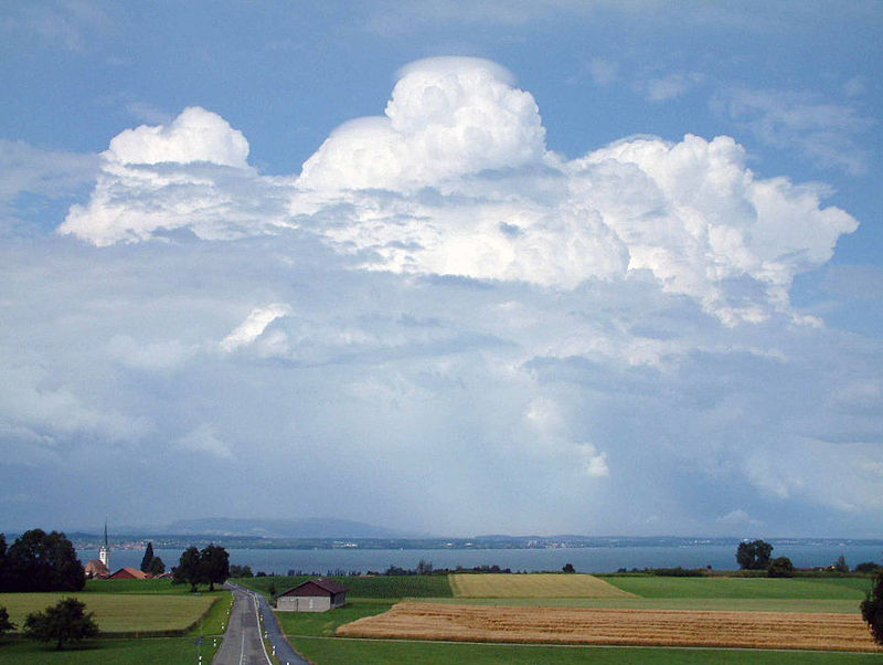
Landschlacht, Switzerland, 8 November 2016
King Solomon of Israel (970 – 932 BC) once wrote about life on Earth in his day:

“A generation goes and a generation comes…
All things are full of weariness.
A man cannot utter it.
The eye is not satisfied with seeing nor the ear filled with hearing.
What has been is what will be.
What has been done is what will be done.
There is nothing new under the sun.
Is there a thing of which it is said, “See, this is new.”?
It has been already in the ages before us.
There is no remembrance of former things, nor will there be any remembrance of later things yet to be, among those who come after.”
(Ecclesiastes 1: 4 – 11, Holy Bible, New International Version)
This is especially true in the Information Age.
Every day we see an endless procession of visual images and listen to an endless stream of sounds.
Yet, after all our looking and listening, our eyes and ears are not satisfied.
We still want to see and hear more.
So we take in more of the endless procession of sounds and images.
Enough is never enough.
There is always one more show to watch, one more game to play, one more song to listen to.
We keep texting, webcasting, Facebooking, Twittering and Flickring.
![]()
![]()

And it is all futile.
Life is more boring than modern man cares to admit.
Empires rise and fall.
War is followed by peace, then followed again by war.
As Yogi Berra said: “It´s déjà vu all over again.”

What really changes?
The message or just the methods and speed?
Sickness or just the diagnostics and treatment?
Relationships?
Politics?
Morality?
The methods have changed, but the essence remains the same.
What was, is.
What is, will be.
Issues thought long past once again revisit.
The past unresolved meets the present moment, creating tensions for the future.
Again the winds of change blow across a familiar landscape.
Economics struggles against nature and tradition.
To be fair, there are moments of optimism.
“Eight miles off the coast of Long Beach, California, the oil rig Eureka, which has stood there for 40 years, looking like just another artifact of the modern industrial landscape, has beneath the waves a vast and thriving community of sea life – one of the richest marine ecosystems on the planet.

The location of Eureka and other rigs like it in this area, where a cold current sweeps down from Canada, has become a perfect habitat for fish and other sea life settling around the massive concrete pylons.
Momentum is gathering to convert rigs into artificial reefs once the rigs are decommissioned.
Awareness is increasing of the value of rigs as permanent homes for sea life.
But leaving rigs in place is controversial and is seen as benefiting the oil industry.
The Eureka, owned by the Houston oil company Beta Offshore, is one of 27 oil rigs off the California coast.

Several major oil spills have occurred since they were built half a century ago, giving rise to a passionate environmental movement that has long advocated complete removal of the rigs.
An enormous oil spill in 1969 released 100,000 barrels of crude, leaving a slick over 40 miles of coastline and killing thousands of animals.
In 2015, a pipeline sprung a leak that released 3,400 barrels of crude into the ocean, fouling several just-created marine protected areas.
The process of removing a rig and cleaning the site, known as decommissioning, is complicated and expensive, and includes plugging and cementing wells to make them safe.
A total decommissioning means the removal of the entire structure.
In a typical rigs-to-reefs effort, only the top portion is removed, usually to a depth of 80 feet, so that they don´t pose any risk to ship hulls.
The rest of the rig remains in place as a haven for sea life and for recreational diving or fishing.
The potential savings to the oil industry from converting all the rigs off the coast of California to reefs could be more than $1,000,000,000, but under US law oil companies would be required to put at least half the money they save into state coffers to fund conservation programs.”
(Erik Olsen, “Oil rigs gushing with marine life”, New York Times, 7 March 2016)
Reading of nature quietly reclaiming places despoiled by man does give me hope that no matter how man wrecks our planet that over time nature will repair itself.
But mankind acts swifter than nature reacts.
“Among Scots and tourists alike, the bonny banks of Loch Lomond have long been renowned as a relaxing place to enjoy some of the country´s most beautiful scenery.

The Australian company Scotgold Resources has spent most of the last decade developing a gold mine in the dramatic surroundings of Loch Lomond and the Trossachs National Park.
Local campaigners are voicing their concerns that the infrastructure and waste created by the operation could damage the national park.”
(The Independent, 25 February 2016)
“The juniper mesas and sunset-red canyons in a corner of southern Utah are so remote that even Republican Governor Gary Herbert says he has probably only seen them from the window of a plane.

This is a paradise for hikers and campers, a revered retreat where generations of the Original Peoples have hunted, gathered ceremonial herbs and carved their stories onto the sandstone walls.
Today, the land known as Bears Ears – named for twin buttes that jut over the horizon – is a battleground in the fight over how much power Washington exerts over federally controlled Western landscapes.

The President has the power under the Antiquities Act of 1906 to create national monuments on federal lands.
A coalition of native tribes, with support from conservation groups, is pushing for a new monument in these red rock deserts, arguing it would protect 1.9 million acres of culturally significant land from new mining and drilling.
But Utah lawmakers are so angry with federal land policies that in 2012 they passed a law demanding that Washington hand over 31 million acres, managed by the Bureau of Land Management, to the state.

The federal government – the landlord of 65% of Utah´s land – has not complied, so Utah is considering a $14,000,000 lawsuit to force a transfer.
Conservative lawmakers across the state have lined up to oppose any new monument.
Ranchers, county commissioners, business groups and even some local tribal members object to a monument as a land grab that would add crippling restrictions on animal grazing, oil and gas drilling and road building in a rural county that never saw its share of Utah´s economic growth.
For the coalition of tribes and nature advocates seeking preservation, a new national monument in Bears Ears would preserve a stretch of mountains, mesas and canyons six times the size of Los Angeles.
It could also create a new model for how public lands are managed.
The tribal coalition of Navajos, Zunis, Hopis, Utes and Ute Mountain Utes wants to jointly manage the land with the government.
“You can´t talk about who we are as a people without talking about the land.
The same kind of love that we have for relatives is no different than the love we have for the land.
Our traditional people know and understand these lands as living, breathing beings.” (Eric Descheenie, chairman of the intertribal coalition)
Utah´s Republican representatives in Salt Lake City and Washington overwhelmingly oppose President Obama and are pushing a bill that would conserve some stretches of land while allowing energy development in other parcels.
Environmental groups have largely denounced the plan, saying it would lead to more roads and traffic in the back country and open eastern Utah to tarsands extraction and new oil drilling.
Tribal groups pushing for a monument say they would have a far weaker voice in how the area was managed.
The Navajos have hunted and lived in the Bears Ears region long before Utah was called “Utah”.
People still go there to hunt elk or deer, gather wood for fence posts and herbs for ceremonies.”
(Jack Healy, “Remote Utah landscape becomes conservation battleground”, New York Times, 12 March 2016)
In a previous blog I wrote about how Oklahoma is being forced to put limits on oil and gas wells because the underground disposal of industrial wastes have triggered large earthquakes and how a health outreach initiative in Colorado is trying to dispel the notion that all tap water is harmful and how tourism operators are urging the Australian government to tackle climate change.
I spoke about how poachers have almost eliminated rhino species in Tanzania and how Australian company Mineral Commodities wishes to mine titanium on traditional South African land thus threatening social tradition and destruction of the local environment.
(See RIP Earth of this blog.)
Change challenges.
Economics versus tradition is a theme that never seems to fade.
Of course, there are voices that suggest there are other ways to satisfy our never-sated hunger for energy and profits, but these voices seem as distant from kind receptiveness as Bears Ears is from Salt Lake City…far away thus forgetable.
Yet some light does shine through the fog…
“In Britain, drivers of hydrogen fuel cell cars will soon be able to fill up at a network of stations that generate their fuel on site from renewable energy.
A ITM Power station in Teddington, southwest London, has opened with the capacity to produce hydrogen during periods when wind turbines are producing more power than the grid needs.
![]()
The station uses electrolysis to generate hydrogen from tap water.
The electrolyser takes power from the grid and can be switched on and off remotely to help the network remain in balance when there is excess supply of electricity.
Fuel cell cars combine hydrogen and oxygen to produce electricity, which powers the motor.

The Teddington station, based at the National Physical Laboratory, can claim to provide genuinely zero emission fuel when its electrolyser is running on renewable power.
ITM Power is opening several more hydrogen fuelling stations this year.
Fifteen are already in operation and the government is helping to fund a further 40 by 2020.
The Teddington station is part of the HyFive Project, an EU scheme that is supporting clusters of fuel cell cars and stations in Britain, Denmark and Germany.”
(Ben Webster, “Eco-filling station hopes to fuel rise of green cars”, The Times, 10 May 2016)
A reduction in carbon emissions from the use of fossil fuels is needed.
The average European emits around 12 tonnes of carbon a year into the atmosphere.
Carbon emissions are causing climate change.
But in some places like the US getting folks to reduce their carbon footprint is difficult.
SUVs (sport utility vehicles)(also known as 4 X 4s) are incredibly popular in the US, despite being dangerous both for pedestrians and the environment.

One in four vehicles sold in the US is an SUV.
SUVs are also gaining popularity in Europe.
SUVs are the most polluting form of passenger transport available.
Each gallon of petrol/gas burned emits more than 12 kilograms of CO2 and SUVs are gas guzzlers, doing as little as 13 miles per gallon.
I recall with bittersweet amusement the animated film Over the Hedge where RJ (a raccoon voiced by Bruce Willis) explains to the foraging animals he recently met how the world of humans operates:

“THAT is an SUV.
Humans ride around in it, because they are slowly losing their ability to walk.”
(Penny, the mother porcupine, voiced by Catherine O`Hara): Jeepers, it´s so big.
(Lou, the papa porcupine, voiced by Eugene Levy): How many humans fit in there?
(RJ): Usually? One.
The West is a car culture.
We love our cars, despite traffic noise, polluted air, dangerous driving, jam-packed streets and urban chaos.
We breathe in dangerous air pollutants and suffer from eye and throat irritation, cancer and damage to the body´s immune, neurological, reproductive and respiratory systems.
We destroy without compassion or concern our ponds, streams, fields and forests to produce electricity for our homes and to power our transportation.
When I read articles like the ITM Power hydrogen fuel station I feel a spark of optimism, but often I fear the world is heading madly towards becoming an environmental dystopia, as predicted by futurists like Thomas Malthus, Harry Harrison and George Orwell, or as feared in movies like Blade Runner, Elysium, No Blade of Grass, Silent Running, Soylent Green and WALL-E.


“The world´s first international treaty that bans or phases out fossil fuels is being considered by leaders of developing Pacific island nations after a summit in the Solomon Islands in June.
The leaders of 14 countries agreed to consider a proposed Pacific climate treaty, which will bind signatories to targets for renewable energy and ban new or the expansion of existing coalmines, at the annual leadership summit of the Pacific Islands Development Forum (PIDF).
![]()
The treaty proposal was received very positively by the national leaders, who seemed convinced that the treaty is an avenue where the Pacific could again show or build on the moral and political leadership that they showed earlier in their efforts to tackle climate change.
The treaty will bind parties to not approve any new coal or fossil fuel mines and not provide any subsidies for fossil fuel mining or consumption.
The parties will ensure universal access to clean energy by 2030 and will establish a Pacific framework for renewable energy to achieve that goal.
The treaty, to be signed next year, will establish compensation for communities that have suffered climate change-related losses.
The treaty also has provisions on climate-related migration and adaptation.”
(Michael Slezak, “Pacific island nations consider world´s first treaty to ban fossil fuels”, The Guardian, 14 July 2016)
Even my part-time employer seems concerned about the environment…
“Starbucks is to try a fully recyclable cup as part of efforts to cut the amount of waste sent to landfills each year.
![]()
The coffee shop chain will be the first retailer to test the Frugalpac, which, according to its manufacturer, is much easier to recycle.
More than 2.5 billion coffee cups are used in the UK every year, but only one in 400 is recyclable, with the rest sent to landfills or incinerated because they are made from paper laminated with plastic, making them hard to process.
Starbucks, which has 850 shops in the UK, has said that it will test the new cup in some of the shops “to see if the Frugalpac cup meets Starbucks standards for safety and quality.”
(Andrew Ellson, “Starbucks leads the way with fully recyclable coffee cup”, The Times, 22 July 2016)
But old habits and old attitudes die hard…
Let´s take a gander at my home and native land of Canada, a country which seems to be experiencing a love-in from many other countries and much of the media, like The Economist (“Liberty moves north: Canada´s example to the world”, 29 October 2016) or Monocle (“Canada calling: why it´s time to take a fresh look north”, November 2016).

According to The Economist, Canada is “a citadel of decency, tolerance and good sense” and says “the world owes Canada gratitude for reminding it of what many people are in danger of forgetting: that tolerance and openness are wellsprings of security and prosperity, not threats to them.”
Yet one does not get the sense that Canada is superior when it comes to deciding between profits and the environment.
“Fort McMurray, Alberta (or “Fort Make Money” as some Canadians nicknamed it) was the kind of place where second chances and fat paychecks beckoned.

Those who settled there were trained engineers, refugees from wartorn countries and dreamers from across Canada and beyond, drawn to a dot on the map in northern Alberta, a city carved out of the boreal forest in a region gushing with oil riches.
Even after the price of crude began to collapse in late 2014, erasing thousands of jobs, many residents managed to hang on, tightening their belts while waiting for the good times to return.
Then on 1 May 2016, smoke and ash filled the sky, the first harbingers of a catastrophic wildfire sweeping around the city.

The entire population of about 88,000 was forced to evacuate, most in a frantic rush.
The blaze consumed whole sections of Fort McMurray, ranking as one of the most devastating fires in Canada´s history.
The fire destroyed over 2,400 homes and buildings, forcing the largest wildfire evacuation in Alberta history.

The inferno continued to spread across northern Alberta and into Saskatchewan, consuming forested areas and impacting the Athabasca oil sands operation 70 km north of Fort McMurray.
A quarter of Canada´s oil production, equal to one million barrels of oil a day, was halted as a result of the fire.
The fire spread across 1.5 million acres before it was declared to be under control on 5 July 2016.
It is estimated that the damage reached about $4 billion, making this the most expensive damge in Canadian history.
The cause of the fire is suspected to be human caused, starting in a remote area 15 km from Fort McMurray.
But even as displaced residents filed insurance claims and picked through piles of donated clothing, many remain adamant about rebuilding the city that gave them a financial lifeline as rare as the source of its prosperity, the largest oil sands reserve in the world.

Until environmentalists challenged the Keystone XL oil pipeline, the city and the Alberta oil sands reserve were little known outside of Canada and the world´s oil companies.
(More on Keystone to follow…)
Attempts to convert its deposits of tarlike bitumen into fuel go back decades and Fort McMurray´s fortunes have risen and fallen with them.
(New York Times, “A Canadian oil boom town left in ashes”, 8 May 2016 / Wikipedia)
But not enough is said about the oil sands operation in respect to environmental impact or indigeous rights before the wildfire struck.
The Athabaska oil sands are large deposits of bitumen or extremely heavy crude oil.
They consist of a mixture of crude bitumen (a semi-solid rock-like form of crude oil), silica sand, clay minerals and water.
The Athabaska deposit is the largest known reservoir of crude bitumen in the world and the largest of three major oil deposits, along with the nearby Peace River and Cold Lake deposits.
Together, these oil sand deposits lie under 141,000 sq. km / 54,000 sq. mi. of boreal forest and peat bogs and contain about 1.7 trillion barrels of bitumen in place, comparable in magnitude to the world´s total proven reserves of conventional petroleum.
Canada´s total proven reserves are the third largest in the world, after Saudi Arabia and Venezuela.
The Athabaska oil sands are named after the Athabaska River which cuts through the heart of the deposit.
Traces of the heavy oil are readily observed on the river banks.
The bitumen was used by the indigenous Cree and Dene First Nations to waterproof their canoes.
In the sands there are very large amounts of bitumen covered over by water-laden peat bog, clay and barren sand.
The oil sands themselves are typically 40 – 60 metres / 130 – 200 ft deep, sitting on top of flat limestone rock.
Bitumen is extracted from the oil sands by surface mining and in situ steam-assisted gravity drainage (SAGD).

20% of the Athabaska sands are shallow enough to recover bitumen by surface mining, using the biggest power shovels (100 or more tons) and dump trucks (400 tons) in the world.
After the bitumen is excavated, hot water and caustic soda (NaOH) is added to the sand.
The resulting slurry is piped to the extraction plant where it is agitated and the oil skimmed from the top.
About two tons of oil sands are required to produce one barrel (1/8 of a ton) of oil.
SAGD is an advanced form of steam stimulation in which a pair of horizontal wells are drilled into the oil reservoir, one a few metres above the other.
High pressure steam is continously injected into the upper wellbore to heat the oil and reduce its viscosity, causing the heated oil to drain into the lower wellbore, where it is pumped out to a bitumen recovery facility.
Critics contend that government and industry measures taken to reduce environmental and health risks posed by these large-scale mining operations are inadequate, causing unacceptable damage to the natural environment and human welfare.
Mining destroys the boreal forest, which is clear cut to allow for mining excavation and bitumen extraction to occur.
Since the beginning of the oil sands development in 1967, there have been several leaks into the Athabaska River polluting it with oil and tailing pond water.
In 1997 Suncor admitted that their tailing ponds had been leaking 1,600 cubic metres of toxic water per day.
This water contains naphtenic acid, trace metals such as mercury and other pollutants.
The Athabaska River is the largest freshwater delta in the world, but with Suncor and Syncrude leaking tail ponds, the amount of polluted water will exceed 1 billion cubic metres by 2020.

Natural toxicants derived from bitumen in northern Alberta pose potential ecological and human health risks to residents living in the area.
Oil sands development contributes arsenic, cadmium, chromium, lead, mercury, nickel and other metal elements toxic at low concentrations to the tributaries and rivers of the Athabaska.
A car filled with fuel from Canada´s oil sands emits 15% more carbon dioxide into the air than average crude oil.
Oil development activities bring an enormous number of people into a fragile ecosystem.
Water is easily polluted because the water table reaches the surface in most areas of muskeg (peat bog).
With the ever-increasing development and extraction of resources, wildlife are recipient to both direct and indirect effects of pollution.
Woodland caribou are particularly sensitive to human activities and as such are pushed away from their preferred habitat during the time of year when their caloric needs are greatest and food is the most scarce.

Humanity´s effect on the caribou is compounded by road construction and habitat fragmentation that open up the area to deer and wolves.
Wildlife living near the Athabaska River have been greatly impacted due to pollutants entering the water system.
An unknown number of birds die each year.
Particularly visible and hard hit are migrating birds that stop to rest at tailing ponds.

There have been numerous reports of large flocks of ducks landing in tailing ponds and perishing soon after.
There has also been a large impact on the fish that live and spawn in the area.
As toxins accumulate in the River due to the oil sands, bizarre mutations, tumors and deformed fish species have begun to appear.
First Nations communities that live around the River are becoming increasingly worried about how the animals they eat and their drinking water are being affected.
There is a higher rate of cancer in their communities caused by the contamination of the River and the oil sands as well as uranium mining.
The world´s largest production of uranium is also in this area.
In July 2015, one of the largest leaks in Canada´s history spilled 5,000 cubic metres of emulsion – about 5 million litres of bitumen, sand and wastewater – from a Nexen Energy pipeline at an oil sands facility.
In January 2016, an explosion left one worker dead and another seriously injured.
(Wikipedia)
So, let´s look at another oil boom region: North Dakota.
North Dakota´s big shale oil boom, which in its heyday produced 810,000 barrels a day, was described as being similar to the California gold rush but in North Dakota in the 21st century.
The Bakken Shale Formation boom was so large that it cut the number of US imports of crude oil and petroleum products in half.
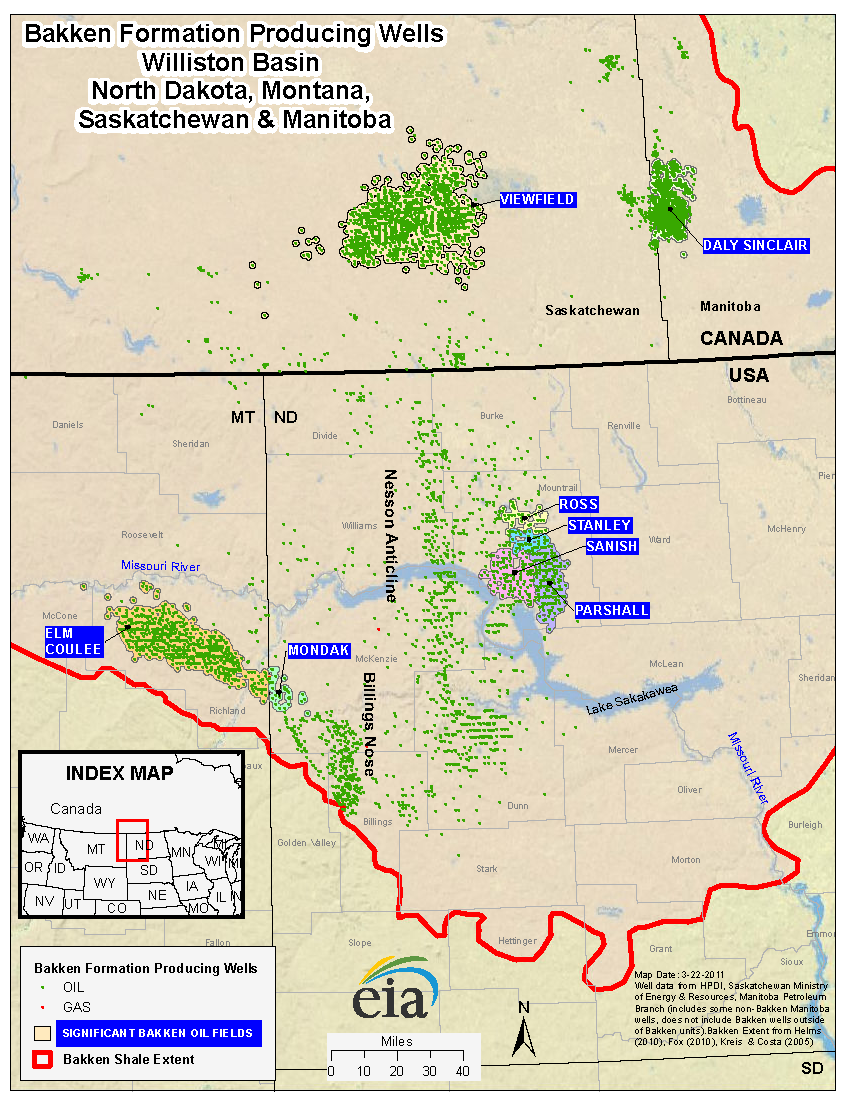
The boom created thousands of jobs and generated millions in wealth, but at a cost…
It took a massive toll on the environment.
Since 2006, there has been more than 19 million gallons of oils and chemicals that have been spilled, leaked or misted.
(New York Times, “The downside of the boom”, 22 November 2014.)
Since 2006, at least 74 workers have died in the Bakken oilfields.
On average that means someone dies in the Bakken oilfields every six weeks.
Oil workers were hired on a 20/10 basis: 20 days working / 10 days off, with some working shifts of 69 hours straight.
And there are few incentives for the oil companies to care about their workers.
The US Department of Labor reported that “the current general industry standards inadequately address the unique hazards encountered on oil and gas wells.”

(Department of Labor´s Occupational Safety and Health Administration (OSHA) report on oil and gas well drilling and servicing, The Federal Register, 28 December 1983)
There are fewer than 10 OSHA inspection officers for the entirety of both North and South Dakota.
It would take decades for OSHA to inspect every worksite in North Dakota.
![]()
On 14 September 2011, at an Oasis Petroleum site in western North Dakota near the town of Williston, an oil well explosion killed 21-year-old derrickman Brendon Wagner and injured three others.
Of the three injured men, one would later die from his injuries, another would have his legs amputated and the third would commit suicide.
OSHA found that the site had been missing many important safety features.
“None of the employees were provided flame retardant clothing…The servicing rig did not have a safety slide.”
(OSHA report, September 2011)
But Oasis was not liable for the damages their oil well caused because the workers had been subcontracted from Carlson Well Service and the “Oasis company supervisor” was contracted from Mitchell´s Oil Field Service.
Meaning that no one working on Oasis´ well that day was actually an Oasis worker.
In an Oasis service contract, dated 21 July 2010, it reads that Carlson had the authority to control and direct the performance and safety of the work and that Oasis was interested only in the results obtained.
Now, the subcontracting of workers is not unique to North Dakota, but what is special to North Dakota is how friendly regulatory authorities are to oil companies operating in the state.
“We have created a friendly business climate in North Dakota.
Taxes and insurance rates are low.
The regulatory environment is very reasonable.
North Dakotans are friendly towards business and will work hard to help their employers be successful.”
(North Dakota Governor Jack Dalrymple, 2012)

Governor Dalrymple heads up the three-person Industrial Commission which overseas the state´s oil and gas regulations and excises fines for the majority of spills.
One of the biggest oil producers in the state is Continental Resources, which has spilled a greater volume of spillage (1.6 million gallons) than any other operator in North Dakota.
Since 2006, Continental has been fined only $222,000, but has paid only $20,000 as the fines are reduced because the Industrial Commission typically settles for 10% of the assessed penalties.
Lynn Helms of the Commission claimed that this system works well due to the conditions which are attached to the penalties:
The penalised company agrees to cut a cheque, which is unappealable if the same or a repeat violation occurs in a one-to-five-year period after the penalised offence.
“In five years, no companies have had a repeat violation.
It´s like Prohibition and really changes behavior.”
(Lynn Helms interview, Associated Press, 20 March 2012)
In 2014, Petro Hunt received a 90% discount on a $20,000 fine after an incident where they spilled 3,000 gallons of oil.
Five months later, in an oil spill one mile northwest of Keene, Petro Hunt had another incident where 600 barrels of oil leaked from a well and was not contained on site.
600 barrels of oil = 2,500 gallons of oil
North Dakota´s regulations extend to political campaign financing.
On 21 July 2014, the Center for Public Integrity reported that “the oil sector is the biggest single source of political contributions in the state of North Dakota”.
“When I first ran for office and was visiting with other candidates I always asked, “If you had any money left in the campaign account at the end of the campaign what do you do with it?”.
One of the most fascinating answers I received was: “What´s wrong? Put it in your checking account. It´s yours. That´s income.”.”

(Utah Democrat Representative Corey Mack)
North Dakota does not have an Ethics Commission.
North Dakota also allows the oil industry to use “indemnification to avoid civil liability”.
A typical service contract, 21 July 2010:
“Contractor agrees to indemnify and hold harmless the Company against all claims without limit and without regard to the cause or causes thereof or the negligence or fault with any party in connection herewith Contractor´s employees on account of bodily injury or death.”
Jobs and money shouldn´t come at the expense of land and lives.
(HBO Last Week Tonight with John Oliver, 10 November 2015 broadcast)
Comfort and convenience, speed and progress, should not mean the sacrifice of lands and lives, the environment or our survival.